


Human Ecology of the Sonoran Desert
In 1922, Aldo Leopold and his brother canoed through the delta of the Colorado River. They hunted quail and geese, watched bobcats swat mullet from driftwood logs, and dreamed of el tigre (jaguar), whose �personality pervaded the wilderness,� even though they never saw any of the big cats. �For all we could tell, the Delta had lain forgotten since Hernando de Alarc�n landed there in 1540,� Leopold mused. �When we camped on the estuary which is said to have harbored his ships, we had not for weeks seen a man or a cow, an axe-cut or a fence� (Leopold 1949, 141). �On the map the Delta was bisected by the river,� the famed conservationist goes on to say, �but in fact the river was nowhere and everywhere, for he could not decide which of a hundred green lagoons offered the most pleasant and least speedy path to the Gulf. So he traveled them all and so did we. He divided and rejoined, he twisted and turned, he meandered in awesome jungles, he all but ran in circles, he dallied with lovely groves, he got lost and was glad of it, and so were we. For the last word in procrastination, go travel with a river reluctant to lose his freedom in the sea.�
By the time Leopold wrote those words in the 1940s, he knew he was writing an elegy, not a paean. The river mighty enough to support a jungle in the desert had already lost its freedom, not to the Gulf of California into which it emptied, but to California farmers and the City of Los Angeles. Beginning in the 1890s, Anglo-American promoters and government engineers strove to break the Colorado to the new Western order. Their first attempts nearly triggered a geological catastrophe, when floods in 1905 sent the Colorado roiling down a canal with no headgate and turned the Salton Sink into the Salton Sea. In 1936, however, a white wall of more than three million cubic yards of concrete rising 726 feet against black rock halted the river in its tracks. Erected to prevent floods and to provide hydroelectric power, Hoover Dam turned the Colorado into a tame ditch for the last 300 miles of its course to the sea. The Colorado and its tributaries, along with the other major rivers that brought water to the Sonoran Desert, such as the Yaqui and the Mayo, became ghosts of the past, victims of the twentieth century, carcasses of sand whose lifeblood had been diverted into cotton fields, copper mines, and vast, sprawling cities.![]()
The Native Americans
Leopold foresaw the transformation and never revisited the delta. �I am told the green lagoons now raise cantaloupes. If so, they should not lack flavor,� he wrote. �Man always kills the thing he loves, and so we the pioneers have killed our wilderness� (Leopold 1949, 148).
The passion of those words rang with recrimination. But they also reflected a deeply American romanticism as well. Leopold felt that he was witnessing the death of wilderness in the Southwest. Like most Anglo-American newcomers, however, he underestimated the impact that native peoples had already visited upon the Southwestern landscape. Much of the Sonoran Desert, after all, had been homeland to American Indians for at least 12,000 years. Their transformations were more subtle, and in most cases more benign, but human groups have shaped the flora and fauna of the Sonoran Desert, including the Colorado delta, for millenia.
Geoscientist Paul Martin believes that Paleoindians armed with stone-tipped spears overhunted the great Pleistocene mammals of North America and helped drive them to extinction. His �Pleistocene overkill� theory is controversial, but prehistoric Indian societies clearly had an impact upon local animal populations.
Analyzing animal bones from hundreds of Hohokam sites in central and southern Arizona, zooarchaeologist Christine Szuter traces a decline in artiodactyls (deer, bighorn sheep, and pronghorn antelope) and an increase in rodents and in lagomorphs (cottontails and jackrabbits) as Hohokam settlements grew larger and more sedentary. In other words, the longer Hohokam lived in an area, the more they hunted out the big game and relied upon rabbits and rodents for animal protein. And as they cleared desert vegetation for firewood and fields, they also harvested more jack rabbits, which fled predation by running across flats, and fewer cottontails, whose instincts told them to dash for cover that was no longer there.
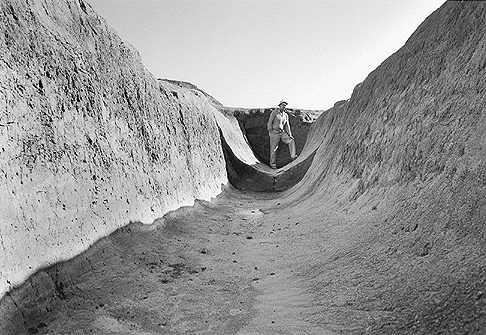 |
| The Sonoran Desert's prehistoric Hohokam were sophisticated desert farmers who built the largest system of irrigation canals in pre-Colombian North America. This section of canal was exposed during the 1964-1965 excavations at Snaketown, located northwest of the present-day town of Sacaton, Arizona. |
The Hohokam were sophisticated desert farmers who built ballcourts, platform mounds, and the largest system of irrigation canals in pre-Columbian North America. But even hunters, gatherers, and fisherfolk manipulated the distribution of plants and animals. The Comc�ac, or Seri Indians, live on the coast of Sonora in one of the driest landscapes on the continent. Seris never cultivated domestic plants or raised domestic animals except dogs, but they did carry certain species of wild plants and animals with them as they moved across the desert and sea. According to ethnobiologist Gary Nabhan and his colleagues at the Arizona-Sonora Desert Museum, their sojourns expanded the range of at least five of the forty-nine species of terrestrial reptiles in Seri territory beyond areas where they naturally occurred.
A case in point is the story of the piebald chuckwallas of Isla Alcatraz in Bah�a Kino. These large lizards exhibit traits from three different species—Sauromalus varius, from San Esteban Island, S. ater from the Sonoran mainland, and S. hispidus from the western midriff islands. During the earlier part of this century, when Asian demand for the swim bladders of totoabas (Totoaba macdonaldi, the largest member of the croaker family) triggered a fishing boom in the Gulf of California, Seri fishermen released chuckwallas and iguanas as survival foods on islands like Alcatraz. On Alcatraz, at least, the chuckwallas interbred to create a larger, meatier reptile. These hybrids are the result of cultural, not natural, processes of biogeographic distribution. Piebald chuckwallas may not rival Hoover Dam, but they do represent human-induced changes in the Sonoran Desert.
Contrary to romantics like ecologist Stanwyn Shetler, pre-Columbian America was not a �pristine natural kingdom� where �the native people were transparent in the landscape, living as natural elements of the ecosphere� (Shetler 1991, 226).
The most intensive way pre-Columbian Native Americans transformed their environments was through agriculture. Archaeologists are finding evidence that so-called �Archaic� peoples were growing maize (corn) at least 3000 years ago in well-watered areas like the Tucson Basin. Then came pinto and tepary beans, gourds, squash, cotton, and a host of other plants including amaranth and devil�s claw. The Cocopas cultivated Sonoran panic grass in muddy sloughs along the Colorado delta. They, like the Quechan, Mojaves, Yoemem (Yaquis), and Yoremem (Mayos), practiced flood-plain-recession agriculture, planting their crops as floodwaters receded. The Hohokam and their successors, the Akimel O�odham (Upper Pimas), on the other hand, dug canals to divert water from Sonoran Desert rivers onto their fields. Hohokam canal systems along the Salt and Gila rivers snaked across the desert floor for nearly 100 miles (160 km) in the Florence area and for 125 to 315 miles (200 - 500 km) in the Phoenix Basin. Hohokam farmers did not use all sections of these canal systems at any one time. Nonetheless, they still irrigated between 30,000 and 60,000 acres (12,000 - 24,000 ha) in the Phoenix Basin alone.
Hohokam farmers also constructed ditches and brush weirs along alluvial fans to divert runoff onto their fields after summer rains. This form of agriculture, sometimes called ak-chin among Tohono O�odham in southern Arizona and temporal among mestizos (people of mixed Hispanic and Indian ancestry)
in rural Sonora, is still being practiced today. North of Tucson, however, the Hohokam developed an enormously labor-intensive type of agriculture that did not survive into the historic period. Archaeologists Paul and Suzanne Fish and their colleagues at the Arizona State Museum discovered more than 42,000 rock piles in association with contour terraces and checkdams on the western slopes of the Tortilita Mountains. They also found huge roasting pits containing charred fragments of agave. The rock piles protected young agave plants from predation by rodents and conserved moisture by reducing evaporation around their bases. During the twelfth and thirteenth centuries, more than 100,000 agaves may have been simultaneously growing in these rock pile fields. ![]()
The Arrival of the Europeans
The Marana community that cultivated those agaves abandoned the northern Tucson Basin in the mid-fourteenth century. About the same time, in the winter of 1358-59 A.D., a massive flood roared down the Salt and Verde rivers, washing out canals and washing away fields in the Salt River Valley. The flood was followed by two decades of drought and more floods in the early 1380s. Hohokam communities along the Salt may never have recovered from those climatic calamities.
Other Hohokam communities along the Gila River survived into the fifteenth century. By the time the first Europeans settled in the region in the late 1600s, however, Hohokam civilization had collapsed. Some archaeologists speculate that centuries of highly mineralized irrigation water may have saturated Hohokam fields with salts until they could no longer produce crops. Others argue that increasing political conflict may have caused Hohokam society to implode. Pima creation narratives describe the ancestors of the O�odham emerging from beneath the earth to destroy �great houses� ruled by powerful priest-chiefs along the Gila River. The conquest begins with Casa Grande and ends with Pueblo Grande, governed by the priest-chief Yellow Buzzard. Many archaeologists believe that the O�odham are descendants of the Hohokam. O�odham creation narratives, in contrast, portray themselves as conquerors.
Regardless of how or why Hohokam civilization disintegrated, the peoples of the northern Sonoran Desert were living much simpler lives when Jesuit missionary Eusebio Francisco Kino and his companions encountered them. We know much less about the pre-Columbian peoples of Sonora because so little archaeological research has been done south of the international border. At the time of initial European contact in the sixteenth century, large populations of Cahita-speakers—the ancestors of the Mayos and Yaquis—lived along the Mayo and lower Yaqui rivers. Opatas and Eudeves dominated the Sonora River valley and the upper Yaqui and its tributaries. So-called Pimas Bajos, or Lower Pimas, occupied a wide crescent between the Opatas and the Yaquis. All of these peoples spoke Uto-Aztecan languages and relied upon agriculture for at least part of their diet.
Once the Europeans arrived, however, one of the greatest ecological revolutions in the history of the world transformed both lives and landscapes. Biological historian Alfred Crosby calls this revolution the Columbian Exchange—that flow of genes, microbes, plants, and animals between the �Old World� of Eurasia and Africa and the �New World� of the Americas. The first revolutionary wave may even have preceded the Europeans themselves: Indians infected with Eurasian diseases like measles, influenza, and smallpox may have unsuspectingly unleashed contagions as they traveled up ancient trade routes from central Mexico. Some archaeologists and ethnohistorians even contend that these diseases may have contributed to the demise of Hohokam civilization itself.
We may never know exactly when the first epidemic spread death and devastation among the Indians of the Sonoran Desert. What we do know is this: thousands of Yaquis and Mayos were perishing when the first Jesuit missionaries ventured into Cahita territory in the early 1600s. The pattern repeated itself again and again at five- to eight-year intervals as Spanish settlers pushed northward into the Opater�a and the Pimer�a Alta. Epidemiologically virgin populations had no genetic resistance or cultural mechanisms to resist the microbial onslaught. Like native peoples all over the Americas, the number of Indians in the Sonoran Desert declined by as much as ninety-five percent over the next two centuries.
For the Indians who endured, however, the Europeans brought new crops, new tools, and new animals that revolutionized their economies and their means of transportation. Winter wheat filled an empty niche in their agricultural cycle because it could be planted in November, when frosts at higher elevations in the Sonoran Desert would have withered corn, beans, or squash. Mules and oxen enabled them to cultivate their fields with wooden or iron plows, intensifying their reliance upon agriculture. Cattle, sheep, and goats allowed them to convert non-edible forbs and grasses into beef, mutton, cheese, milk, leather, and tallow. Horses expanded their ranges and shrank distances. A Euro-American agropastoralist economy—irrigation agriculture along the floodplain, animal husbandry in the uplands—supplemented, complemented, and slowly replaced digging-stick agriculture and wild food gathering.
Cattle, horses, and mules had other consequences as well. In November 1697, Kino and his frequent traveling companion Juan Mateo Manje visited Sobaipuri Pimas along the Baboc�mari River in southeastern Arizona. They found O�odham performing a circular dance around a tall pole dangling nine scalps. Sixteen Janos and Jocome raiders had tried to run off their small herd of livestock—livestock they had received from the Jesuit missionary. Kino�s gifts of cattle and horses had made O�odham along the San Pedro River targets of Jocome, Janos, and Apache raiding. Because of those raids, O�odham along the San Pedro eventually had to retreat to the Santa Cruz River Valley, while Pimas along the Gila River organized themselves into larger villages with a standing army of 1000 men�nearly one-fourth their total population. The introduction of Old World livestock into the Sonoran Desert triggered a pattern of raiding and retaliation between O�odham and Apaches that lasted for 200 years.![]()
Spaniards and Mexicans
That same pattern made mission Indians and Hispanic frontiersmen allies of one another, as their guerrilla warfare with the Apaches intensified. Spaniards and their mixed-blood descendants were a minority in the Sonoran Desert until the mid- to late-eighteenth century. That meant that even though they exploited Indian labor and encroached upon Indian land, they also depended upon Yaquis, Mayos, Opatas, and Pimas for their very existence on a dangerous frontier.
Some groups, such as the Yaquis, kept Hispanic colonists from penetrating their territory until the late 1800s. Among the Opatas and Lower Pimas, on the other hand, Spaniards, mestizos (Spanish-Indian), coyotes (mestizo and Indian), and mulattos settled in or near mission communities despite the protests of the missionaries. Mestizaje—racial mixture—weakened ethnic boundaries, as competition for arable land and irrigation water increased in Sonoran Desert river valleys. Those river valleys—the Sonora, the Bavispe, the Santa Cruz—became riparian oases of Hispanic civilization in the desert.
Stock raising was the most land-extensive Euro-American transformation of the Sonoran Desert. Cattle, horses, goats, and sheep searched for forage from river floodplains to mountain crests. In more settled areas like central Sonora, overgrazing became endemic during the Spanish colonial period. The presidio (military garrison) and town of Pitic (modern Hermosillo) alone ran 5000 head of cattle, 3422 sheep, 435 goats, 2138 horses, and 367 mules in 1804 (Radding 1997, 218). But Apache hostilities prevented ranchers from expanding beyond the Santa Cruz Valley in southern Arizona. During the 1820s and 1830s, the Mexican government issued nine land grants in southern Arizona. All were largely abandoned by the 1840s. Hispanic stock raising never was sustained enough to have a widespread impact upon the southern Arizona landscape except along the Santa Cruz.
Apache attacks also checked the northward expansion of mining, the most land-intensive industry in Hispanic Sonora. In less vulnerable areas, however, mining lured thousands of Indians and non-Indians alike from strike to strike. There were two types of mining communities in the region. The discovery of silver in 1683 south of the R�o Mayo led to the development of Alamos, a city of wealth and social stratification based upon the enormous capital investment required to extract and process silver ore. Cieneguilla in northwestern Sonora, on the other hand, was a desert boom town where gambucinos (prospectors) dry-winnowed alluvial deposits for particles of gold. Vein-mining operations like that of Alamos depended upon large, stable labor forces organized into hierarchies of occupations. Placers like Cieneguilla attracted restless, mobile congregations of Spaniards, mestizos, Yaquis, Opatas, and Pimas, most of whom worked for themselves. No other economic activity so thoroughly rearranged social relationships on New Spain�s and then Mexico�s northern frontier.
The same could be said about mining�s impact upon local and regional environments. Most placers faded into the desert, however, while silver-mining districts like Alamos or San Juan Bautista in the R�o Moctezuma Valley continued to generate voracious demands for charcoal, timber, firewood, tallow, salt, and mercury for decades and even centuries. To supply these mining districts, stock ranches also proliferated, creating what geographer Robert West (1949) calls the �ranch-mine
settlement complex.� Complex webs of economic relationships linked farflung mining communities with merchant and imperial capital in Mexico City and Madrid. Meanwhile, hillsides were denuded, streams diverted, water tables polluted, and vegetation communities irrevocably changed.![]()
Anglo-Americans
Those social and ecological patterns replicated themselves after the United States wrested away more than half of Mexico�s national territory during the Mexican War of 1845-1848. Gold and silver lured Anglo-Americans and Europeans to the northern Sonoran Desert—first along the Colorado River as placer booms like the one at La Paz flared and faded, then in the mountains along the Hassayampa River, where the town of Wickenburg sprang up to reduce and mill silver ore. Precious metals were the only commodities worth the enormous transportation costs on such an isolated and dangerous frontier.
And Arizona was a frontier for the first three decades of its existence as a part of the United States. From the arrival of the Europeans until the 1880s, the Arizona-Sonora borderlands were a frontier in the most basic sense of the term�contested ground where no single tribe, empire, or nation held uncontested sway. Because Apaches, Yavapais, and River Yumans resisted European and Euro-American conquest so successfully for two centuries, Euro-American impact upon the desert environment was intermittent rather than sustained.
That all changed in the 1880s, when the Era of Extraction began. In 1877, the Southern Pacific Railroad reached Fort Yuma on the Colorado River. Three years later, after its largely Chinese crews had laid tracks across some of the hottest, driest terrain in North America, the railroad steamed into Tucson. At the gala celebration on March 20, 1880, Mexican intellectual Carlos Velasco raised a toast to the �irresistible torrent of civilization and prosperity� that would follow the steel rails. Six years later, when Geronimo surrendered to General Nelson Miles for the final time, the frontier came to an end. Suddenly, Arizona and Sonora were safe for global capital, which poured in from the eastern United States, California, and the British Isles, as the Southern Pacific and other railways extended their arteries of commerce across deserts and mountains. Both Arizona and Sonora became extractive colonies of the industrial world, their natural resources ripped from the ground and shipped somewhere else for finishing, processing, and consuming. In Arizona, this was the era of the �Three C�s,� when cattle, copper, and cotton dominated the economy.
The first major extractive industry to explode across the landscape was stock raising. In 1870, there were perhaps 38,000 head of cattle in the Arizona Territory. By the early 1890s, there were about 1,500,000 head of cattle and more than a million sheep, many of which had been shipped into the territory by rail. Stock raising expanded south of the border as well, as investors like Colonel William Henry Greene put together vast ranches on the grasslands of northern Sonora. Pascual Encinas even drove his cattle onto the coastal plains west of Hermosillo, establishing his famous Costa Rica Ranch at Siete Cerros on the edge of Seri territory. Encinas tried to train the Seris as laborers and offered them religious instruction. But as more ranchers moved onto their desert hunting and gathering grounds, the Comc�ac responded by killing cattle for food. By the late nineteenth century, the �Encinas War� erupted, pitting cowboys armed with repeating rifles against Seris armed with bows and arrows. The Comc�ac were decimated. Sonora�s march to the sea began.
The second major extractive industry—copper mining—depended even more heavily upon the railroads. Unlike gold and silver, copper was an industrial rather than a precious metal. The evolution of the industry therefore became the triumph of technological innovation over declining grades of ore. Staggering amounts of earth had to be moved to extract a metal that eventually constituted less than one percent of its ore bodies, and that earth had to be moved from mine to smelter in railroad cars, not in freight wagons or on the backs
of mules. In copper districts like Bisbee, where Phelps Dodge Corporation�s Copper Queen reigned supreme, thousands of miles of shafts and tunnels burrowed underground. And while most of these early districts were in
the uplands fringing the Sonoran Desert, Phelps Dodge and other giants eventually chewed into the desert as well, particularly after open-pit mining became feasible. At Ajo, Mammoth, Twin Buttes, and Silverbell, giant holes begat gargantuan slag heaps, which rose above the desert floor like pyramids erected in honor of the Electrical Age.![]()
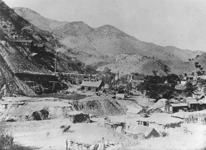 |
| An 1890s photograph of Bisbee, Arizona. The Copper Queen mine is left center. |
Water Control and the Transformation of the Desert
The third major extractive industry—agriculture—led to the ultimate transformation of the Sonoran Desert. For 3000 years, farmers had cultivated their crops along those few stretches of the desert where surface water flowed near arable land. In Sonora, the major agricultural areas were located in the river valleys of the zona serrana, the mountainous central and eastern portions of the state. Generally trending northeast-southwest, successive mountain ranges and river valleys cradled Opata, Eudeve, and Lower Pima communities. During the Spanish colonial period, the serrana attracted Spaniards and their mestizo descendants as well, who raised wheat, fruits, vegetables, and sugar cane along its cottonwood-shaded floodplains.
After Mexico won its independence from Spain in 1821, however, Guaymas became Sonora�s most important port of entry, and a strong commercial axis between Guaymas and Hermosillo (formerly Pitic)�the gateway to the serrana�developed. Merchants and military officials cast covetous eyes on the rich coastal floodplains of western and southern Sonora, particularly the Yaqui and Mayo river valleys. The Yaquis fought a bloody war of resistance but by the late nineteenth century, the Hiakim, or Yaqui homeland, had been occupied by the Mexican army. The Sonoran state government under Governor Rafael Iz�bal then decided to eliminate the Yaquis once and for all by deporting thousands of Yoemem to the Oaxaca Valley or to henequ�n plantations in the Yucat�n. It was cultural genocide in the service of �order and progress.�
Speculators soon descended upon the Yaqui Valley with grand plans to irrigate the coastal plains. In 1890, the Mexican government granted Carlos Conant Maldonado 300,000 hectares (one hectare, or ha = 2.47 acres) along the R�o Yaqui, 100,000 ha along the R�o Mayo, and 100,000 ha along the R�o Fuerte in northern Sinaloa in return for surveying the area and building canals along each river. Conant�s Sonora and Sinaloa Irrigation Company, incorporated in New Jersey with U.S. capital, soon went bankrupt, but the Richardson Construction Company purchased Conant�s grant in 1906. In exchange for selling 400-hectare blocks of land and supplying irrigation water to colonists, most of them from the United States or Europe, the Compan�a Constructora Richardson, S.A. received exclusive right to sixty-five percent of the R�o Yaqui�s flow for ninety-nine years.
The Richardson brothers had big plans to build storage dams on the Yaqui to generate electric power and furnish water to a network of canals capable of irrigating 300,000 hectares. The Mexican Revolution and World War I destroyed their enterprise but the dream of transforming the Yaqui Valley into a vast grid of irrigated agribusiness bore fruit in 1952, when the Mexican government completed Alvaro Obreg�n Dam at Oviachi forty miles away. Along with dams upriver, the Oviachi reservoir controlled flow along the lower R�o Yaqui and eventually channeled its water into three major canals that irrigate nearly 600,000 acres in the Yaqui Valley. Ciudad Obreg�n, a city of more than 500,000 people, arose to service the largest irrigation district in Sonora. Recognizing the Yaqui Valley�s importance, the Rockefeller Foundation established a wheat-breeding station on the outskirts of Obreg�n under the direction of Dr. Norman Borlaug. This station became one of the hearths of the Green Revolution, that controversial program that dramatically increased wheat production—all of it dependent upon high inputs of chemical fertilizers and pesticides—around the world.
North of the Yaqui Valley, advances in pump technology after World War II allowed other coastal irrigation districts to bulldoze desert plains and convert them into wheat and cotton fields. The largest was the Costa de Hermosillo where, at its height, 887 pump-powered wells regurgitated water onto more than 100,000 hectares. But discharge exceeded recharge by 250 percent. As water tables plummeted and salt water intruded from the Gulf of California, the Mexican government finally stepped in and halved the amount of water that could be pumped. Many fields were abandoned. Other farmers switched from relatively low-value crops like cotton to high-value, high-risk crops like brandy grapes, citrus, garbanzo beans, and vegetables destined for U.S. markets.
Because of these developments, Sonora�s demographic, political, and economic center of gravity shifted from the serrana to the coast during the twentieth century. Dam-building and groundwater pumping enabled capital-intensive agricultural districts to plow under great mesquite bosques (forests) west of Hermosillo and desert ironwood plains around Caborca. Those twin pillars of modern water control also allowed older cities like Hermosillo (about 800,000 population) to expand, and entirely new cities like Cuidad Obreg�n to spring up like an industrial flower south of the dry channel of the R�o Yaqui. But whether these flowers are perennial or ephemeral remains to be seen. Hermosillo already experiences severe water shortages during dry seasons and dry years. Groundwater districts like Caborca and the Costa de Hermosillo are contracting painfully as aquifers drop and pumping costs escalate. Even the Yaqui Valley with its huge reservoirs faces an uncertain future as the North American Free Trade Agreement (NAFTA) reshapes Mexican agriculture. Most farmers in the valley now plant wheat in the winter and soybeans in the summer. As subsidies are removed and trade barriers lowered, many question whether Sonoran producers can compete with Canadian and U.S. farmers dry-farming the same crops.
In Arizona, the future of agriculture is held hostage to urban growth. During the early twentieth century, the newly created Reclamation Service (precursor of the U.S. Bureau of Reclamation) erected Roosevelt Dam in 1903 on the Salt River east of Phoenix and turned the Salt River Valley into one of the largest agricultural centers in the Southwest. And when a British embargo on long-staple industrial cotton during World War I triggered Arizona�s cotton boom, commercial agriculture spread south across the saltbush and creosote bush flats between Phoenix and Tucson. Arizona became one of the leading cotton producers in the world.
But World War II and the postwar boom thrust Arizona from the Era
of Extraction into the Era of Trans-formation, turning an overwhelmingly rural state into an overwhelmingly urban one. Thousands of acres of citrus and cotton sprouted subdivisions and malls as Phoenix and its satellites sprawled into a metropolis of more than 2,500,000 people by 1995. Metro Tucson approached 750,000. By the time the Central Arizona Project (CAP)—a farmer�s dream since the 1920s—reached Maricopa, Pinal, and Pima counties, many farmers could not afford its water. The CAP became one more bargaining chip in the water game, that escalating contest that pitted relentlessly expanding cities against farmers, miners, and Indian nations. ![]()
Visions and Nightmares
Water has always been the ultimate limiting factor on human society in the Sonoran Desert. Until the late nineteenth century, people largely relied upon surface flow, adapting to rivers rather than making the rivers adapt to them. This century, however, dams have domesticated all major rivers in the region while pumps have mined groundwater aquifers far beyond recharge. Arizona�s 1980 Groundwater Management Act mandates that �safe-yield� (when discharge does not exceed recharge) be reached by the year 2025 in four Active Management Areas which together are home to eighty percent of Arizona�s population. Certain areas of the Sonoran Desert may indeed see population growth slowed or halted because they are running out of water.
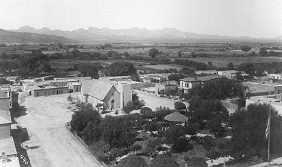 |
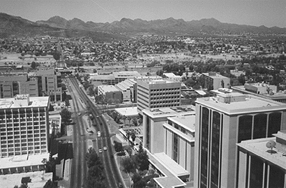 |
| The twentieth century has seen the transformation of Arizona from an overwhelmingly rural state to an overwhelmingly urban one, as seen in these two photos of Tucson: about 1900 (top) and 1999 (bottom). Both photos taken at the intersection of Scott and Congress. |
But other areas like metropolitan Phoenix will spread unchecked as long as they can wrest more water away from farmers and Indian nations. For much of its history as a part of the United States, Arizona has suffered from a bad case of �California envy,� battling its more powerful western neighbor for Colorado River water, yet emulating its explosive growth. Unless it consciously decides to restrict growth, however, Arizona will become the southern California of the twenty-first century. Metropolitan Phoenix will embrace five to seven million people. Tucson will reach 1,500,000 and learn to guzzle the CAP water it has twice refused to drink in the 1990s. Ambos Nogales (two cities of the same name separated by the international boundary) may resemble El Paso-J�arez if free trade and the maquiladora (assembly plant) program keep on luring millions of Mexicans to the border. And since most of Arizona and Sonora�s population now live in the Sonoran Desert, the urban assault will only intensify.
Meanwhile the Columbian Exchange continues to rearrange the countryside. Since 1942, the number of non-native plants in Arizona alone has risen from 190 to approximately 330 species. During the 1930s, agents of the Soil Conservation Service promoted a South African grass called Lehmann lovegrass to control erosion. Today it covers more than 400,000 acres of Arizona. Beginning in the 1960s, Sonoran range scientists introduced another African grass—buffelgrass— to increase forage production. More than one million acres of desert and subtropical thornscrub have now been scraped away to plant this exotic. Ecologist Tony Burgess of Columbia University�s Biosphere II calls such proliferation the �Africanization of the Sonoran Desert.�
Aldo Leopold may have under-
estimated past peoples� manipulation
of the Southwestern landscape. He would have shuddered at how utterly
we have transformed the Sonoran Desert since he and his brother drifted along the green lagoons.![]()
References
Leopold, Aldo. A Sand County Almanac and Sketches Here and There. London: Oxford University Press, 1949.
Radding, Cynthia. Wandering Peoples: Colonialism, Ethnic Spaces, and Ecological Frontiers in Northwestern Mexico, 1700-1850. Durham: Duke University Press,1997.
Shetler, Stanwyn. �Three Faces of Eden.� Seeds of Change: A Quincentennial Commemoration. Herman J. Viola and Carolyn Margolis, eds. Washington, D.C.: Smithsonian Institution Press, 1991.
West, Robert. �The Mining Community in Northern New Spain: The Parral Mining
District.� Ibero-Americana. Berkeley: University of California Press, 1949. ![]()
Additional Reading
Bahre, Conrad. A Legacy of Change: Historic Human Impact on Vegetation of the Arizona Borderlands. Tucson: University of Arizona Press, 1991.
Bowden, Charles. Killing the Hidden Waters. Austin: University of Texas Press, 1977.
Fradkin, Philip. A River No More: The Colorado River and the West. Tucson: University of Arizona Press, 1984.
Nabhan, Gary. Gathering the Desert. Tucson: University of Arizona Press, 1985.
Reisner, Marc. Cadillac Desert: The American West and Its Disappearing Water. New York: Penguin Books, 1986.
Sheridan, Thomas. Arizona: A History. Tucson: University of Arizona Press, 1995. ![]()
A Sense of Our Place in the Sonoran Desert
Following is a selection of books from Desert Stories: A Reader�s Guide to the Sonoran Borderlands, an Arizona-Sonora Desert Museum Sense of Place Project publication.
Contemporary Scene
Burckhalter, David. La Vida Norte�a: Photographs of Sonora, Mexico. Albuquerque: University of New Mexico Press, 1998.
Miller, Tom. On the Border: Portraits of America�s Southwestern Frontier. NY: Harper & Row, 1981.
Nabhan, Gary. Desert Legends: Re-Storying the Sonoran Borderlands. New York: Henry Holt, 1994.
Weisman, Alan. La Frontera: The United States Border with Mexico. Tucson: University of Arizona Press, 1986.
Yetman, David. Sonora: An Intimate Geography. Alburquerque: Univ. of New Mexico Press, 1996. ![]()
History
Clarke, Asa Bement. Travels in Mexico and California. Texas A&M University Press, 1988 (originally published in 1852).
Lumholtz, Carl. New Trails in Mexico: An Account of One Year�s Exploration in North-Western Sonora, Mexico and South-Western Arizona, 1909-1910. Tucson: University of Arizona Press, 1990.
Martinez, Oscar. Border People. Tucson: Unversity of Arizona Press, 1994.
Pfefferkorn, Ignaz. Sonora: A Description of the Province. Tucson: Univ. of Arizona Press, 1989. ![]()
Native American Cultures
Fontana, Bernard. Of Earth and Little Rain: The Papago Indians. Flagstaff: Northland Press, 1981.
Griffith, James S. Beliefs and Holy Places: A Spiritual Geography of the Pimer�a Alta. Tucson: University of Arizona Press, 1992.
Kelley, Jane Holden. Yaqui Women: Contemporary Life Histories. Lincoln: University of Nebraska Press, 1978.
Sheridan, Thomas E. and Nancy J. Parezo. Paths of Life: American Indians of the Southwest and Northern Mexico. Tucson: University of Arizona Press, 1996.
Underhill, Ruth. Singing for Power. Tucson: University of Arizona Press, 1993. (Originally
published in 1938). ![]()
Natural History and the Environment
Abbey, Edward. Cactus Country. New York: Time-Life, 1973.
Alcock, John. Sonoran Desert Summer. Tucson: University of Arizona Press, 1990.
Bowden, Charles. Sonoran Desert. New York: Harry N. Abrams, 1992.
Hayden, Julian D. The Sierra Pinacate. Tucson: Southwest Center Series, University of Arizona, 1998.
Hornaday, William T. Camp-fires on Desert and Lava. Tucson: University of Arizona Press, 1983. (First published in 1908).
Krutch, Joseph Wood. Desert Year. Tucson: University of Arizona Press, 1985.
Nabhan, Gary. The Desert Smells Like Rain. San Francisco: North Point Press, 1981.
West, Robert C. Sonora: Its Geographic Personality. University of Texas Press, 1993. ![]()