


Regional Natural History and Image Galleries
Images & Descriptions of the Sonoran Desert
- Lower Colorado River Valley
- Arizona Upland (including seasonal images & descriptions)
- Plains of Sonora
- Central Gulf Coast
- Vizcaino
- Magdalena
- Foothills of Sonora
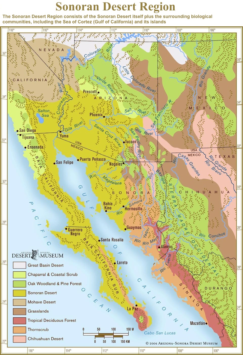
Sonoran Desert Region
What is the Sonoran Desert Region?
The region interpreted by the Arizona-Sonora Desert Museum consists of the Sonoran Desert itself and the included and adjacent habitats that influence its ecology and climate. More specifically, it includes:
- Southern Arizona north to the Mogollon Rim
- The southeastern corner of California (roughly south of a line drawn from Needles to Palm Springs to San Diego)
- The state of Sonora, Mexico
- The Baja California peninsula of Mexico
- The Gulf of California and its islands
Biomes
The Sonoran Desert Region is rich in both habitats and species. Because of our location on the western edge of a continent in the horse latitudes, we have biotic communities representing all of the world's biomes:
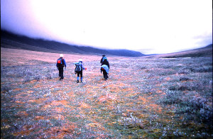
Tundra occurs on the San Francisco Peaks near Flagstaff, Arizona, which rise above timberline to 12,600 feet. There, only 45 miles (72 km) from the northernmost saguaros of the Sonoran Desert (just north of the Mogollon Rim and not in the sonoran Desert proper), can be found some of the same plant species that grow in Alaska.
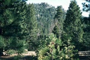
Coniferous forest occurs in the higher mountain ranges throughout the Sonoran Desert. This Rocky Mountain montane forest is the dominant vegetation of the cold- temperate Rocky Mountains. Its elevation increases southward until it is pushed off the tops of the mountains by excessive aridity and warmth in Mexico. In the mountains west of the Sonoran Desert are isolated islands of Sierran (as in Sierra Nevada) coniferous forest, characterized by different species of conifers and other plants.
Temperate deciduous forest is strictly represented only by scattered aspen groves and ribbons of riparian trees. But the foothills and lower mountain slopes of the Sonoran Desert's sky islands, and mountains east of the Sonoran Desert are wooded with oaks and pines, a mixture of coniferous forest and temperate deciduous forest tree types. This Madrean evergreen woodland (also called Mexican oak-pine woodland) is a warm-temperate community of the Sierra Madre Occidental. It extends as far north as central Arizona, where it is squeezed out by the cool-temperate Rocky Mountain forests above it and the more arid grassland and desert below.
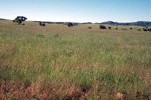
Grassland in our region is mostly the semidesert grassland community, intermediate between desert and Great Plains grassland. Desert grassland or chaparral border the northern Sonoran Desert on the east and also occur on the lower slopes of the sky islands.
Chaparral borders the western edge of the Sonoran Desert in California and northern Baja California, the northeastern edge along the base of the Mogollon Rim of Arizona, and occurs in small patches on the higher sky islands.
Desert is the driest biome. Our center of interest is the Sonoran Desert. The other three North American deserts - the Mohave, Chihuahuan, and Great Basin, also occur in Arizona, the only state to have all four. See below for more details.
Thornscrub looks like a wet desert, and that's essentially what it is. It is intermediate between the desert and tropical forest biomes. The Sonoran Desert gradually merges into thornscrub in south-central Sonora and southern Baja Calfornia, Mexico. Part of the Sonoran Desert was recently reclassified as thornscrub, and other parts may soon be as well.
Tropical Forest is represented by tropical deciduous forest in southern Sonora and the cape of Baja California Sur. It's verdant during the brief summer rainy season and dry and mostly leafless the other nine months.
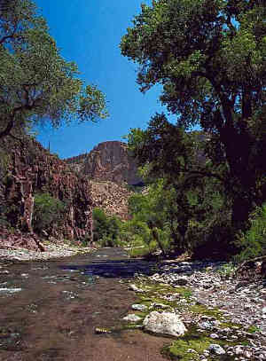
Riparian Communities are not biomes. Though they could be considered isolated ribbons of deciduous forest, they are better viewed as a unique habitat type. Several perennial and intermittent rivers flow through our region, the biggest being the Colorado. Desert ecologists include the vegetation in washes (arroyos) as "dry riparian" habitats. Though they may carry water only a few days a year or even less, they share most of their defining characteristics with traditional "wet" riparian habitats. They are chronically disturbed, unstable sites where water and nutrients are harvested and concentrated from larger areas (watersheds). Like wet rivers, washes are corridors for dispersal of plants and animals that need more water than the surrounding habitat.
The North American Deserts
North America has four major deserts: Great Basin, Mohave, Chihuahuan and Sonoran. Though all are defined primarily by their aridity, their different temperature and precipitation patterns have created distinctly dissimilar biotic communities.
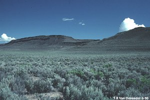
The Great Basin Desert is both the highest and northernmost of the four and has very cold winters, which limit the growing season to the summer regardless of seasonal precipitation. Vegetation is dominated by a few species of low, small-leafed shrubs; there are almost no trees or succulents and not many annuals. The indicator (most common or conspicuous) plant is big sagebrush (Artemisia tridentata), which often grows in nearly pure stands over huge vistas. (Such cold shrub-deserts in the Old World are called steppes.)
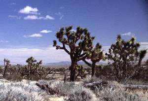
The Mohave Desert is characterized largely by its winter rainy season. Hard freezes are common but not as severe as in the Great Basin Desert. The perennial vegetation is composed mostly of low shrubs; annuals carpet the ground in wet years. There are many species of these two life forms, but few succulents and trees grow there. The only common tree species is the characteristic Joshua Tree (Yucca brevifolia), an arborescent (treelike) yucca that forms extensive woodlands above 3000 feet (900 m) elevation.
Though the Chihuahuan Desert is the southernmost, it lies at a fairly high elevation and there is no barrier to arctic air masses, so hard winter freezes are common. Its vegetation consists of many species of low shrubs, leaf succulents, and small cacti. Trees are rare. In the northern end there is occasionally enough winter rain to support massive blooms of spring annuals.
The Sonoran Desert
The Sonoran Desert as currently defined covers approximately 100,000 square miles (260,000 sq. km.) and includes most of the southern half of Arizona, southeastern California, most of the Baja California peninsula, the islands of the Gulf of California, and much of the state of Sonora, Mexico. It is lush in comparison to most other deserts. Two visually dominant life forms of plants distinguish the Sonoran Desert from the other North American deserts: legume trees and columnar cacti. It also supports many other life forms encompassing a rich spectrum of some 2,000 species of plants.
The amount and seasonality of rainfall are defining characteristics of the Sonoran Desert. Much of the area has a biseasonal rainfall pattern, though even during the rainy seasons most days are sunny. From December to March frontal storms from North Pacific Ocean occasionally bring widespread, gentle rain to the northwestern areas. From July to mid-September, the summer monsoon brings surges of wet tropical air and frequent but localized violent thunderstorms.
The Sonoran Desert prominently differs from the other three North American Deserts in having mild winters; most of the area rarely experiences frost. About half of the biota is tropical in origin, with life cycles attuned to the brief summer rainy season. The winter rains, when ample, produce huge populations of annuals (which comprise half of the species in our flora).
Subdivisions of the Sonoran Desert
Forrest Shreve defined seven vegetative subdivisions in the 1950s. One (the Foothills of Sonora) has since been reclassified as foothills thornscrub, a non-desert biome. The status of two other subdivisions - Arizona Upland and Plains of Sonora - may also be reclassified.
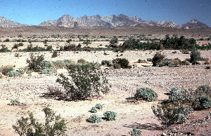
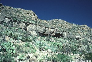
Lower Colorado River Valley — Named for its location surrounding the lower Colorado River in parts of four states, this is the largest, hottest, and driest subdivision. It challenges the Mohave Desert's Death Valley as the hottest and driest place in North America. Summer highs may exceed 120 F (48.5 C), with surface temperatures approaching 180 (82 C). The intense solar radiation from cloudless skies and low humidity (often less than 10%) suck the life-sustaining water from exposed plants, water that cannot be replaced from the parched mineral soil. Annual rainfall in the driest sites averages less than three inches (75 mm), and some localities have gone nearly three years with no rain. Even so, life exists here, abundantly in the rare wet years. See additional images in the report on Ironwood Forest National Monument.
The geography is mostly broad, flat valleys with widely-scattered, small mountain ranges of mostly barren rock. There is also a sand sea (the Gran Desierto) and the spectacular Pinacate volcanic field. The valleys are dominated by low shrubs, primarily creosote bush (Larrea divaricata) and white bursage (Ambrosia dumosa). These are the two most drought- tolerant plants in North America, but in driest areas of this subdivision even they are restricted to drainage courses (i.e., they become riparian plants!). Trees are found only in the larger washes. The mountains support a wider variety of shrubs and cacti, but the density is very sparse. Columnar cacti, one of the indicators of the Sonoran Desert, are rare (virtually absent in California) and restricted to drainages. Annual species comprise well over half the flora (90% at the driest sites); they are mostly winter-growing species and appear in numbers only in wet years.
This is the only part of the Sonoran Desert that extends into California, where it is usually called the Colorado Desert. North of a sagging line between Palm Springs and Needles, California, it merges almost imperceptibly with the lower Mohave Desert.
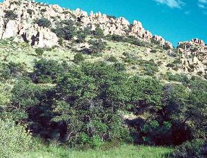
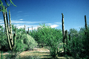
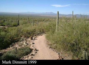
Arizona Upland — (Image galleries are associated with each season below. See more images in the Ironwood Forest National Monument web pages.)
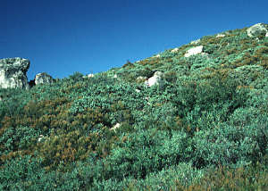
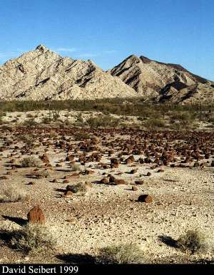
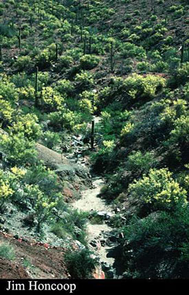
This northeastern section, mostly in south-central Arizona and northern Sonora, is the highest and coldest subdivision of the Sonoran Desert. The terrain contains numerous mountain ranges, and the valleys are narrower than in the Lower Colorado River Valley subdivision. Trees are common on rocky slopes as well as drainages, and saguaros are found everywhere but on the valley floors. This community is also called the saguaro-palo verde forest. It is the only subdivision that experiences frequent hard winter frosts, so many species of the lower elevation and more southerly subdivisions cannot survive here. Nevertheless it is a rich area. The small range that is the Desert Museum's home, the Tucson Mountains, has a flora of more than 630 taxa.
An ever-increasing number of biologists is concluding that the Arizona Upland's climate, vegetation density, and biodiversity resemble thornscrub more than desert. Don't be surprised if this subdivision is reclassified as thornscrub in the future.
Tucson is the only major city located in Arizona Upland. Residents who moved to this city from temperate climates often complain about the lack of seasons. Actually Arizona Upland has five seasons, which, though more subtle than the traditional temperate four, are distinct if one learns what to look for:
Summer monsoon or summer rainy season (early July to mid-September):
The year traditionally begins with the most dramatic weather event of the region - the often abrupt arrival of the summer rains. A tropical air mass adds humidity and moderates June's extreme temperatures; frequent thunderstorms; main growing season for many of the larger shrubs and trees. (Monsoon is an Arabic word for a wind that changes directions seasonally. Be aware that it does not refer to rain or storms in any way. The word is often misused, even by some weather forecasters.)
Autumn (October & November):
Warm temperatures; low humidity; little rain; few species in flower, but beginning of growing season for winter annuals in the rare years with enough rain. Autumn and late summer occasionally receive heavy rains from the remains of Pacific hurricanes (tropical storms) This image is of the Baboquivari Mountains and the Avra Valley from the Desert Museum.
Winter (December & January & February):
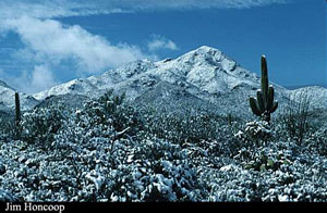
Mostly sunny, mild days, with intermittent storms with wind, rain, and cool to cold temperatures; February often warm and dry, more spring-like. This image shows a rare snowfall in the Tucson Mountains.
Spring (From early to late February through April):
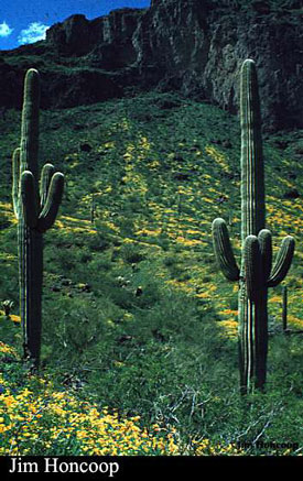
Mild temperatures; little rain; often windy; main flowering season for annuals, shrubs and trees; winter annuals may bloom in February in warm, wet years. The image at left shows poppies at Picacho Peak State Park.
Foresummer drought (May & June):
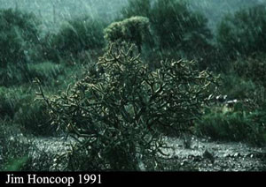
High temperatures; very low humidity; no rain in most years; May is very warm and often windy; June is hot and usually calm. There is little biological activity except for the flowering and fruiting of saguaro, foothill palo verdes (as seen at left), and desert ironwood trees. Nearly every living thing is in basic survival mode until the rains arrive.
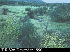
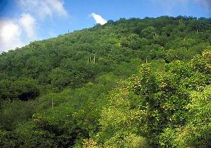
Plains of Sonora — This small region of central Sonora is a series of very broad valleys between widely separated ranges. It supports denser vegetation than Arizona Upland because there is more rain (with summer rain dominant) and the soils deeper and finer. It contains most of the same species as Arizona Upland, plus some more tropical elements because frost is less frequent and less severe. There are abundant legume trees, especially mesquite, and relatively few columnar cacti. The few hills in this region support islands of thornscrub. Most of this subdivision has been converted to agriculture in the last few decades. If Arizona Upland is reclassified as thornscrub, the wetter Plains of Sonora subdivision would have to join it.
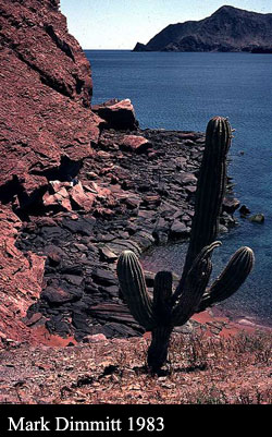
Central Gulf Coast — The Central Gulf Coast occupies a strip along both sides of the Gulf of California. Extreme aridity determines the distinctive appearance of this subdivision. It straddles the horse latitude belt, and desert vegetation grows right to the seashore. Small shrubs are nearly absent; their shallow root systems and lack of water storage cannot sustain them through the droughts which commonly last for several years. Dominating the vegetation are large stem-succulents, particularly the massive cardón (Pachycereus pringlei), and trees such as palo verde, ocotillo, ironwood, elephant trees (Bursera spp.), and limberbush (Jatropha spp.) which are leafless most of the time. The average annual rainfall of less than five inches (125 mm) occurs mostly in summer, though not dependably enough to call it a rainy season.
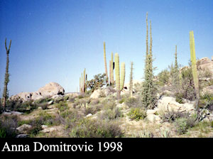
Vizcaino — The Vizcaino subdivision is on the Pacific side of the central third of the Baja California peninsula. Though rainfall is very low, cool, humid sea breezes with frequent fog ameliorate the aridity. Winter rain predominates and averages less than five inches (125 mm). This subdivision contains some of the most bizarre plants and eerily beautiful landscapes in the world. There are fields of huge, sculpted white granite boulders or black lava cliffs that shelter botanical apparitions such as boojums (Fouquieria columnaris), twisted and swollen Baja elephant trees (Pachycormus discolor), 60-foot tall cardónes (Pachycereus pringlei, a giant relative of saguaro), strangler figs (Ficus petiolaris palmeri) that grow on rocks, and blue palm trees (Brahea armata). In stark contrast, the coastal Vizcaino Plain is a flat, cool, fog desert of shrubs barely a foot tall, with occasional mass blooms of annual species.
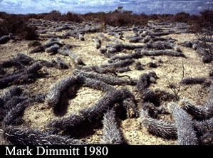
Magdalena — Located in coastal Baja California south of the Vizcaino, it is similar in appearance to the Vizcaino but the species are somewhat different. Most of its meager rainfall comes in summer and the aridity is modified by Pacific breezes. The bleak coastal Magdalena Plain's only conspicuous plant is the weird creeping devil cactus (Stenocereus eruca), but inland the rocky slopes are rich and dense with trees, succulent shrubs, and cacti.
Foothills of Sonora — This was Shreve's seventh subdivision of the Sonoran Desert. It has since been reclassified as foothills thornscrub community and is no longer part of the desert biome because of its greater rainfall, taller trees and cacti, and denser vegetation.