Patterns of Rain
Generally speaking, the Sonoran Desert averages only three to fifteen inches (76 to 400 mm) of rain a year. In the Arizona Upland subdivision of the Sonoran Desert, rain falls about equally in two rainy seasonsŚa winter one in December and January, and a summer one in July through early September. August, September and December are the regionÆs wettest months; May and June are the driest. While there are local variations depending on elevation and proximity to mountains, this pattern basically holds for the entire area.
Rainfall here is infrequent and undependable. The most salient feature of rainfall is not so much its rarity, but its variability, or capriciousness, to put it in terms of human personality. The rain does not fall in even patterns. Sometimes rainfall over a summer will be recorded in small showery increments, but often the rain falls in a few large storms. And while not ōnormal,öit isnÆt unusual for a single storm to produce fifty percent more rain than typically falls in a whole year. Yuma, Arizona, for example, is one of the driest places on earth, averaging about 3H inches (89 mm) a year. Yet deluges in the past have dumped over four inches (100 mm) in a single day.![]()
Why It Doesn't Rain Much in the Sonoran Desert
This area's climate is, in a word, dry. Ringed by mountains that keep the rain away for much of the year, the Sonoran Desert quietly bakes. Moist air moving east from the Pacific Ocean is forced to rise over the Cascades and Sierra Nevada, cooling as it rises. Since cool air cannot retain as much water vapor as warmer air can, the excess water precipitates. Moisture blowing in from the ocean is effectively drained, and the air that moves down the ranges' eastern slopes is usually so dry it cannot produce any more rain. This phenomenon, the rain shadow effect, describes such aridity on the inland side of coastal mountains.
The dependability of our warm, cloudless, often windless, days is primarily the result of what's called the North Pacific high pressure zone, and is related to the circulation of the earth's atmosphere. (See the Communities of the Sonoran Desert Region"for more information.) Air that heats up at the equator rises, as warm air does, and moves poleward, until it cools enough to sink at roughly 30░ latitude (north and south)Śwhere many of the planet's deserts lie (see map on page 11). As this equatorial air descends upon the Sonoran Desert region, it creates a very stable and warm atmosphere. The rains stay away until the high pressure system weakens, allowing moisture to slip into the region.![]()
Pipe Dreams
The excitement of a summer rain reminds us that water is precious in this arid environment. Long periods of drought are the norm, and desert plants and animals are adapted to water scarcity. But what about the millions of people now living in the burgeoning cities of the Sonoran Desert region? From 1990 to 1997 alone, Phoenix grew by 22 percent and its metropolitan population topped 2,600,000.
With per capita water use exceeding 300 gallons per day in Phoenix, the aridity of the desert seems to impose little restraint on these modern desert dwellers. New golf courses appear to spring up every week in our desert cities (Phoenix and Tucson alone had more than 200 public and private golf courses in 1998). This, despite the fact that each 18-hole golf course uses an average of 185 million gallons of water annuallyŚthe equivalent of 3500 single family homes!
How can the desert supply all this water? The answer is that it can't. Rainfall replenishes only a fraction of the fossil groundwater withdrawn every year from ancient aquifers laid down thousands of years ago. (The aquifer underlying central Tucson has fallen by more than 200 feet in the last 50 years.) To supplement depleting groundwater supplies, distant river basins are diverted through massive water projects to transport water into this arid region.
By mining fossil groundwater and importing river water from more humid climates, the residens of the Sonoran Desert have buffered themselves from the reality of their arid environment. This dependence on imported and non-renewable sources of water must be addressed in planning for the long-term sustainability of our desert cities.![]()
Summer Rains Ś The Big Tease
The word monsoon refers to a system of winds that changes seasonally, bringing wet and dry periods to a region. In the Sonoran Desert, the summer monsoon consists of winds from the sea flowing inland to fill the partial vacuum created by rising continental air warmed by the summer sun. These winds bring moisture. The belt of westerlies shifts north in the summertime so that the Pacific high sits around 40░ latitude, allowing moist air from the Pacific off of Baja California to move into the region.
These westward-moving winds actually circle around into the area and often reach the Sonoran Desert as southeasterly winds. This is one reason people in the past assumed that monsoon moisture comes from the Gulf of Mexico. Recent studies, however, lead many meteorologists to believe that most moisture from the southeast is drained by the 6500 foot (1980 m) Mexican Sierra Madre and so doesn't reach the Sonoran Desert. This issue is yet unresolved.
Once Pacific moisture reaches our area, usually in July, the increased humidity means we really begin to feel the heat. If June has proceeded as usual, the desert surface is very hot, causing the moist air moving in to expand and rise. The hot air rising off the desert floor moves upward in great columns called thermals, which can be three to five miles (5 to 8 km) in diameter. Broader areas of cooler air separate the thermal columns, which is why thunderheads can be so wildely scattered. The creation of thermals can be a violent business, and local updrafts can move at over fifty feet (15 m) per second. The strong convection upwards is usually matched by strong downdrafts which kick up sand and dust as they hit the land. Above, the air cools as it rises, until at about 17,000 feet (5200 m) the moisture freezes. A growing thunderhead can tower 40,000 feet (12,000 m) or more, with the whole top containing a raging snowstormŚa strange concept to a person broiling at ground level.
And even with all the buildup, it is not at all uncommon to have a "frustrated"thunderstorm. Towering cumulus clouds sweep across valley floors, whirling skirts of wind and dust, and throwing lightning bolts. Yet all the rain can evaporate before reaching the ground. This creates one of the more awesome desert sights: virgaŚthe trailing vaporous streams of rain that hang from a thunderhead with frayed ends drying in the layer of hot air over the desert's surface.
The rain that does reach the desert floor in a summer thunderstorm typically does so with great vigor. Although the dry desert can absorb substantial amounts of water, much of the rain rolls off the hard-baked ground. Sheets of water wash across the land, filling arroyos and riverbeds in minutes, the flow carrying along sand, rocks, and plants, carving new stream channels and eroding stream banks. This runoff is a critical resource for desert life, whether it is providing a temporary pool for a desert spadefoot (Scaphiopus spp.), a cool spell and source of groundwater recharge for urban desert dwellers, or irrigation for a Tohono O'odham squash field.![]()
Winter Rain Ś A More Lasting Affair
If summer monsoons are torrid affairs Ś never predictable in terms of the next tempestuous rendezvous Ś winter storms resemble somewhat more stable relationships. While winter precipitation is, in fact, as variable as summer rain, the precipitation is often more predictable, since storm tracks can become established. For example, during the winter months, the westerlies shift south to about 35░ latitude and the major storm track brings winter storms off the Pacific to the northwest and into the Great Plains region. This usually produces no more than partly cloudy skies and strong winds in the northern part of the Sonoran Desert.
Occasionally, however, a trough of low pressure forms over the western United States, causing the prevailing flow to push storms further south along the west coast, sometimes as far as San Francisco, and then across the mountains to the Sonoran Desert. Meteorologists can detect the storm approaching the coast and warn desert dwellers days ahead of time that a storm has entered California and will soon reach the Sonoran Desert region. Even the mountains can't keep all the moisture away. Although these storms are embedded in fast-moving air currents and don't usually linger more than a day or two, they are important sources of gentle, soaking rain. (Desert dwellers in Sonora, Mexico typically call winter rains las equipatas, or "little packages"of rain, in contrast to summer rainsŚlas aguas, "the waters.") Once the airflow pattern is established it tends to persist, so that several storms will follow one another over the course of several weeks. This frequently also means that when it rains in Tucson, it is dry in Seattle and vice versa.![]()
Tropical Rain Ś One Heck of a Date
Another manner in which rain comes to the Sonoran Desert is by tropical cyclones, which originate in the eastern part of the North Pacific, usually in the early fall. These giant storms have established some of the all-time records of monthly precipitation in the Sonoran Desert region. The Spanish word chubasco is frequently used by Sonoran Desert dwellers to refer to these tropical storms. ("Chubasco"is more generally defined as any extremely violent storm.) Although infrequent, these storms are memorable.
Consider, for example, some statistics from the flood of 1983. About 10,000 people were displaced. Water, mud and debris severely damaged or destroyed over 1300 homes; 1700 received lesser damage. Many people who fled from their homes were cut off from help because roads, bridges, phone lines, and electric lines were washed away. Interstate 10, the main link between Phoenix and Tucson, was washed out at the Gila River, and twenty other main highways were closed. Nine people drowned trying to cross flooded washes; four others were killed when aircraft got caught in downbursts and crashed.
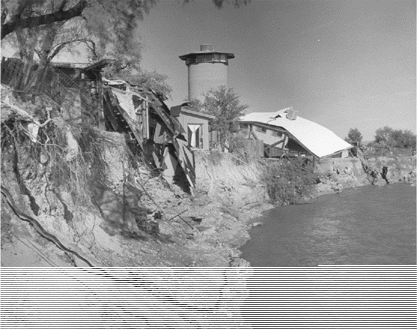
Flood Damage along Tucson's Rillito River, October 1983.
These large storms begin out at sea, and, as they churn over Baja California, the storms pick up additional energy from the warm waters of the upper Gulf of California. They reach the Sonoran Desert region with renewed energy. The Yuma area is frequently hardest hit, occasionally receiving its whole annual allotment of precipitation in a matter of hours. Even when the storm remains at sea it can still produce heavy rains in the desert. In 1970 and 1983, the tropical storms Norma and Octave pounded the Pacific side of Baja California. Moisture moved up into the Sonoran Desert region from the south, met a cold front moving into the area from the north and caused tremendous flooding across the area. Tropical storms are a normal part of the weather pattern, and they have visited the Sonoran Desert region once or twice per decade in recent times.![]()
El Ni±o in the Sonoran Desert
El Ni±o generally refers to a naturally occurring, unpredictable condition in which warm water "pools"in the western Pacific. This occurs when trade winds, which typically keep the ocean water circulating, weaken. The pool of warm water drifts eastward toward South America, causing atmospheric pressure gradients along the equator to weaken, and trade winds to diminish even more. Changes in the ocean temperatures reinforce changes in atmospheric circulation, and the two sets of changes intensify and drive each other, though neither one is clearly the initiator of El Ni±o.
One result of these "chicken-and-egg"changes is that the powerful tropical Pacific storms begin to form farther east than usual, and the jet stream over the northern Pacific Ocean is invigorated and pulled farther south. More moisture and more storms are thus carried to the southwestern U.S. and northern Mexico. El Ni±o events increase the likelihood and severity of winter storms in the Sonoran Desert region. They can also increase the chance of tropical storms from the eastern Pacific. Floods have occurred more often in many Arizona rivers during El Ni±o events than in other years. We also typically see more winter days with more rainfall, while the northwestern U.S. typically sees fewer days with high precipitation. El Ni±o events usually last for several seasons. Typically, during the spring, the seasonal cycle reasserts itself, and the tropical ocean cools back to normal temperatures. Sometimes the warm El Ni±o events give way to unusually cold sea-surface temperatures, a condition called La Ni±a. The effects of the El Ni±o and La Ni±a on global climate are, in part, mirror images of each other, and drought is a common occurrence in the Sonoran Desert region during a La Ni±a event.![]()