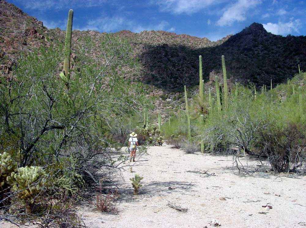
Biological Survey of Ironwood Forest National MonumentGeologic Aspects of Ironwood Forest National Monument by Robert Scarborough
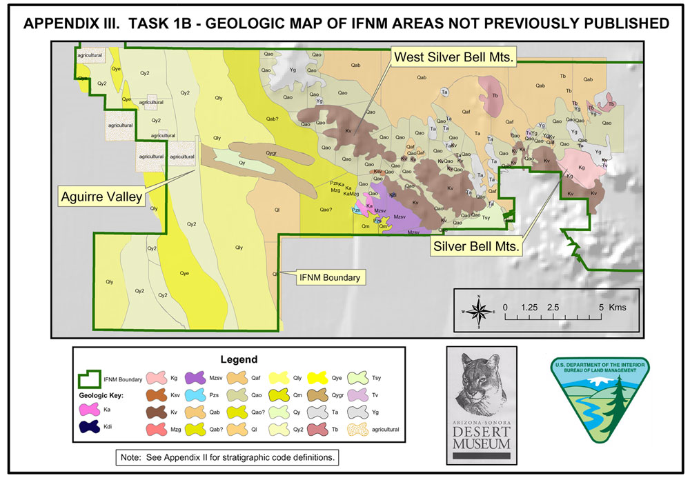
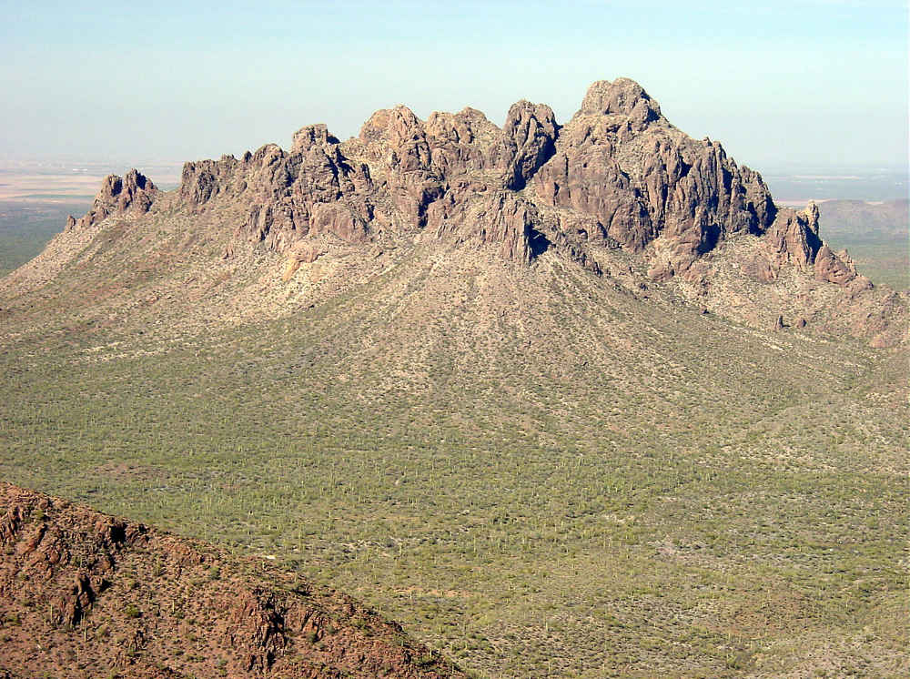
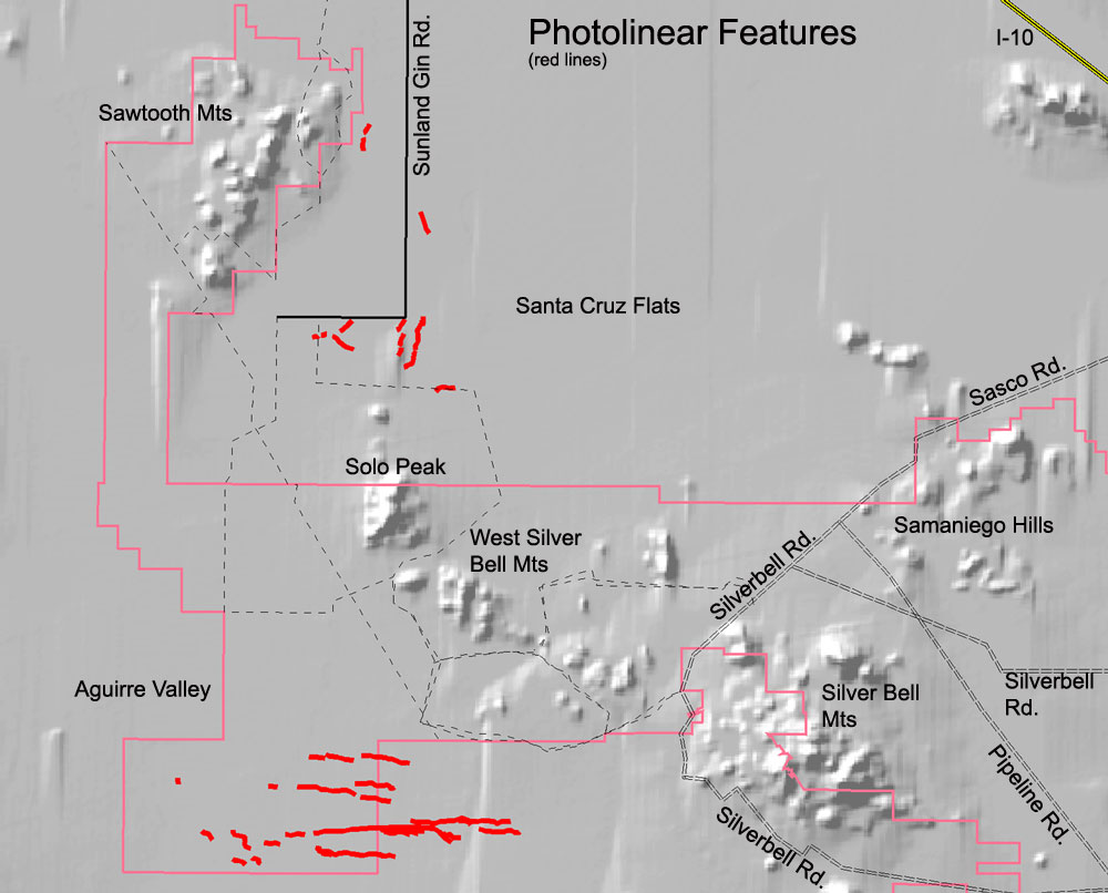
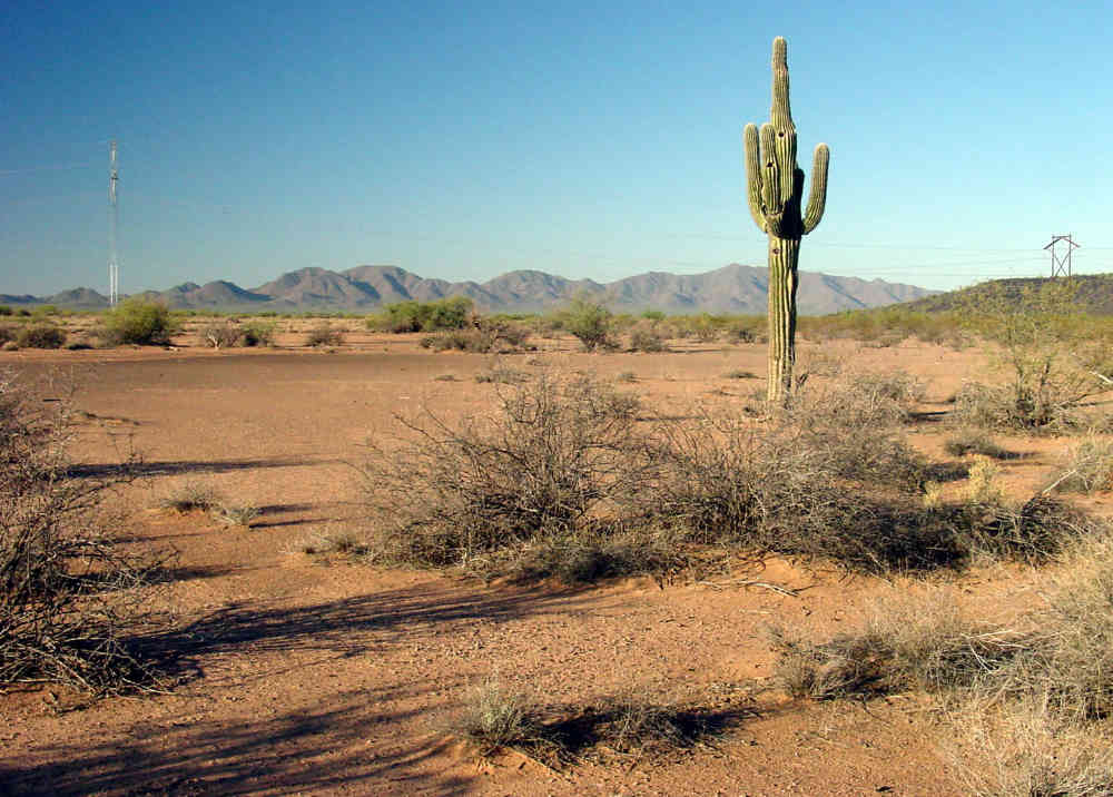
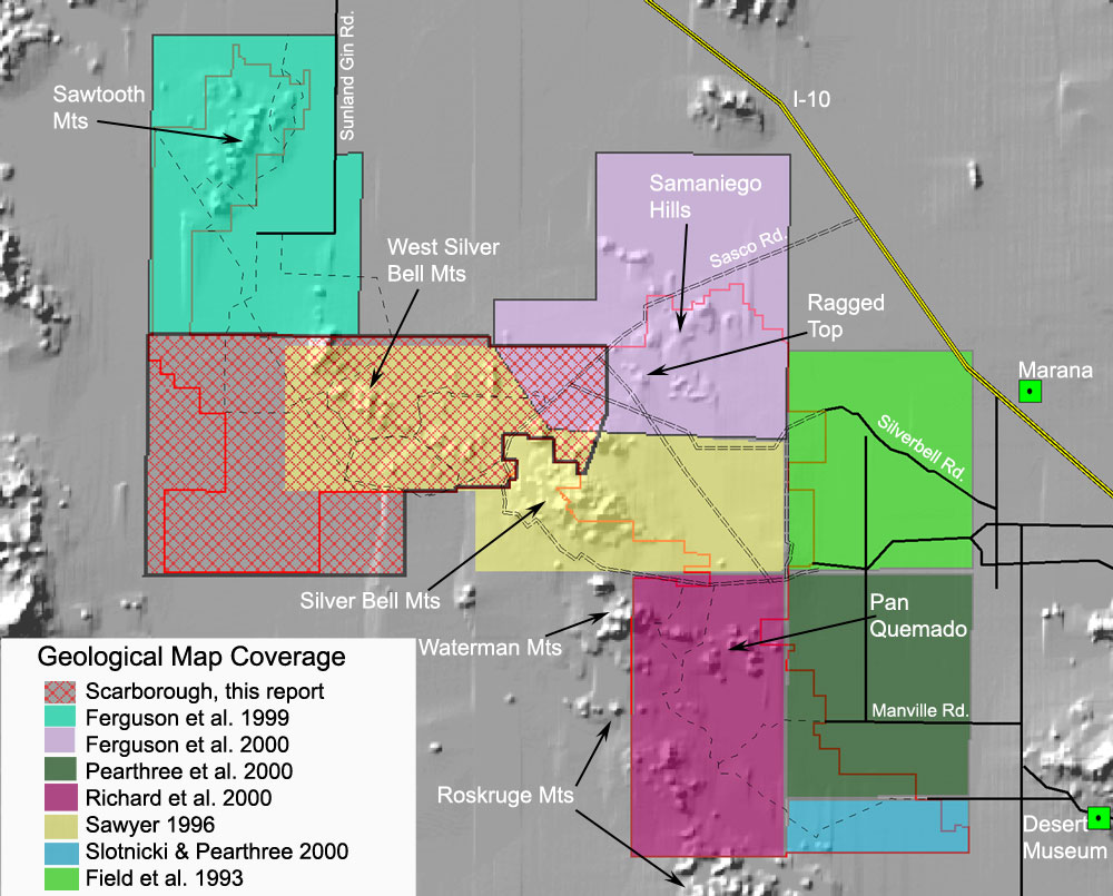
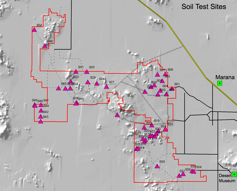
INDEX Geological products for this report Geological products for this report All but a southwestern corner of Ironwood National Monument has been mapped geologically. To complete coverage of the Monument, a simple geologic map was compiled and produced, with some new field work in Quaternary units, for the unmapped region. This phase of the ASDM report consists of: 1. This summary report on the geology of the Monument , including a geologic reference list covering publications that are directly relevant to the Monument (but not including numerous publications directed at the economic geology at Silver Bell mining district). 2. Appendix 1 to this report lists 50 sites in the Monument where Quaternary soils were studied, and a CD Rom index map showing the locations of these 50 sites. It is not the goal of this synthesis to fully describe the soil series present. For that depth of information, the Natural Resources Conservation Service should be consulted, which has appropriate detailed soils information, and regional soil series descriptions published on-line. 3. A geologic map for the unmapped portion of the Monument, in a portion of the Aguirre Valley south of the Sawtooth Mountains, extending eastward to near Silver Bell mine. This map is outlined in item #4, below. Bedrock geology on this map is highly simplified from Sawyer (1996). Preliminary depiction of some cross-valley photolinear features are given on a CD Rom map layer. 4. An index map showing existing geologic map coverage for the Monument, on accompanying CD Rom. 5. A map showing photolinear features on, and directly adjacent to the Monument, which may represent earth fissures or subsidence cracks, likely due to strong groundwater pumping in the 20th century. A new set of cracks which are not reported in the literature were found on a photomontage of the southwestern Monument. General Statement - Deep-Time Geologic background Ironwood National Monument lies in the southern Basin and Range geologic province of western North America, the defining character of which is a general northwest-southeast grain to the distribution of mountain ranges and valleys, characterized by elongate and narrow mountain ranges separated by broad flat valleys, with range crests separated by some 25-30 miles. This anisotropy was produced within the past 30 million years by a unique 'Basin and Range disturbance' which stretched, broke, and distended a large portion of the continental crust of the North American cordillera, reaching at this latitude (32 degrees) from its westward extreme under the shallow Pacific Ocean continental borderland, eastward to somewhat east of El Paso, Texas. Much of this crustal distension occurred during a pulse of interaction between western North America and the adjacent Pacific Ocean tectonic plate some 13-8 million years ago. The shearing action shattered the crust and produced a series of sub-parallel blocks which foundered by some 8,000-12,000 feet relative to mountaintops (called graben blocks), which were subsequently filled in by great thicknesses of sediments, typically including gravels, sands, silts, clays, even including salt and gypsum beds of great bulk in some valleys. The maximum sediment thickness near valley centers typically ranges from 3,000 to in excess of 5,000 feet. These sediment-filled valley segments contain the region's principal unconfined aquifers. The Avra Valley aquifer is under intense management by Tucson Water, now beginning large-scale underground temporary storage of CAP canal water, as future water supply for the city. The water table under the City of Tucson recharge ponds has already risen by more than 40 feet in places. All valleys contain a main 'trunk stream' which courses along or near the valley's center. The Santa Cruz River of the Tucson valley maintains moderate grade along its northward course downstream to the Marana region, where the gradient drops, causing flooding outside the channel during high storm runoff events (such as in 1983 and 1992). The low grade of the Santa Cruz River below Picacho Peak area prompted developers of the early 1900s to dig 'Greene's canal' west from the natural channel to just east of the Sawtooth Mountains where an artificial 'Greene's Reservoir' was engineered, in hopes of supplying irrigation water for crops; today the bermed reservoir itself is totally infilled with agricultural development. For subsequent flow and flood history of the area, see Wood, et. al. (1999). Brawley Wash, which traverses Altar and Avra Valleys south to north, contains somewhat lower gradient, and has clearly ponded during late Pleistocene time into several cienegas ('swamps'), located in the region generally west of the town of Marana, and into which were deposited some calcareous mudstones, which contain a poorly studied mammalian fauna, including mammoth ( Mammuthus columbi ) and camel ( Camelops sp .). Similar ponded marl deposits have not been noted along Aguirre Wash, but could be shallow buried because, like Brawley Wash, the south-to-north valley gradient is quite low. As debris was shed from the mountains into the adjacent valleys, the mountain flanks were eroded down to stream level or grade which persisted for a long time, and consequently the modern mountains are surrounded by a 1-3 mile wide shoulder of very shallow-buried bedrock, termed a buried pediment. The pediments extend from the mountain fronts into the valleys to the position of the buried Basin and Range faults, which run parallel to the mountain long axes, but in a complex 'dog-leg bending' pattern. The position of the edges of the buried grabens is not easy to define, and can be located only by geophysical (gravity) means or actual drilling. The pediment edges are not perfectly known in the Avra Valley, nor in the Aguirre Valley. Knowledge of the extent of these buried pediments, besides being critical in understanding geologic history, influences surface soils and vegetation only when the surficial sediments are very shallow. This condition occurs generally quite close to mountain fronts. In the region, some 70% of all land is covered by Quaternary sedimentary sequences, the remainder consisting of mountains which contain and expose older bedrock, of all ages and origins. The geologic maps referenced in this report indicate a wide variety of rock units that are recognized by recent re-mapping efforts of personnel of the Arizona Geological Survey (140 W. Congress, Tucson, 520-770-3500), during 1994-98. The only bedrock areas not covered by their effort is part of the West Silver Bell Mountains, which is covered by a summary geologic map by David Sawyer, released as a U.S.G.S. Open-file Report in 1996, also available at the State offices. Major hardrock series within the Monument, classified from oldest to youngest, include: (1) granites and schists of middle Proterozoic age (1600-1400 m.y. old - Precambrian), (2) a section of quartzites, shales and conglomerates, and minor limestone of the late Proterozoic-age Apache Group which is found as scattered outcrops across much of southwestern and central Arizona (1350-1100 m.y. old); (3) a surprisingly complete section (though tectonically thinned) of Paleozoic clastic and fossiliferous carbonate sedimentary rocks, best exposed in the Waterman Mountains, upon some limestones of which is found growing the rare 'Turks Head' cactus. Narrow tectonic slices of upper Paleozoic carbonates, with beds now tilted into nearly vertical positions, are found in the southern West Silver Bell Mountains. These rocks are 540-250 m.y. old. The nearly complete section in the Waterman Mountains has been tectonically thinned and metamorphosed, and now dips 20-30 degrees to the east, and is surrounded by fault contacts. (4) a complex series of sedimentary and volcanic rocks of Jurassic and Cretaceous age, including good representatives of some enigmatic bright red/brown-colored 'redbeds', and Laramide granites and volcanic rocks, comprising the bulk of the Roskruge Mountains, and host to a major Laramide porphyry copper deposit at Silver Bell. This series is 180-60 m.y. old. Certain volcanic units are thought to continue into the Tucson Mountains to the southeast (Sawyer, 1996). (5) volcanic rocks and sedimentary rocks of Cenozoic (Oligocene and Miocene) age. Both the Samaniego Hills and the Sawtooth Mountains consist of a flat-lying series of early Neogene (27-20 m.y.) volcanic flows and sediments, 400-600 meters thick. Descriptions are found in Ferguson, et. al. (2000). Sediments interbedded into the flow rocks in the northern Sawtooth Mountains contain mammal tracks exposed on a bedding surface (Ferguson, et. al. (2000), unit Ttx, p. 23). This volcanic assemblage is widespread throughout the Cordillera, and is closely associated with the Basin ands Range geologic province. This series is 35-15 m.y. old in this region.
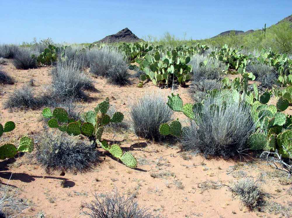
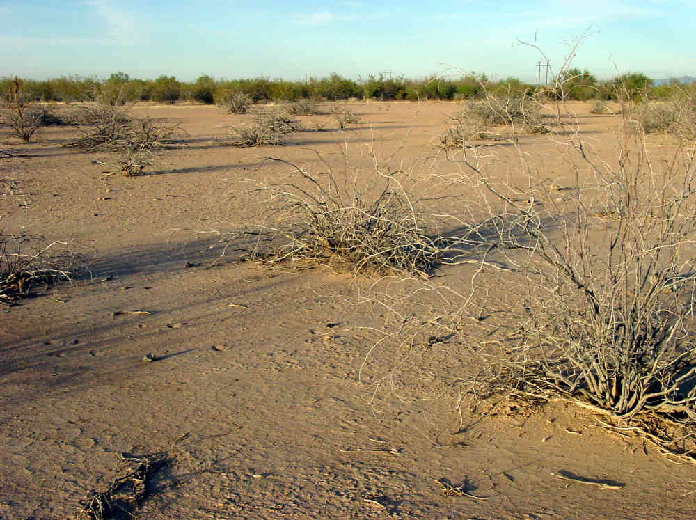
Valley areas between rugged bedrock hills in most parts of the Waterman and northern Roskruge Mountains contain some poorly fossiliferous pink-orange sandstones of presumed Cretaceous age, but possibly also Paleogene age. Some sedimentary rocks of Cretaceous age south of the Monument along the eastern flank of the Roskruge Mountains contain a suite of marine (some possibly freshwater) invertebrate fossils (Stoyanow, 1949), likely part of the regional Bisbee Group. This suite may possibly be present in poorly exposed locations within the Monument. One hundred years of mining geology and history references may be found in Sawyer's (1996) reference list, as well as in Titley and Anthony (1989). Metals recovered at Silver Bell include copper, molybdenum, lead, zinc, silver, along with small amounts of gold. The abandoned Silver Hill mine on the south flank of Waterman Peak was a high-grade skarn-type lead-zinc-copper mine developed in Paleozoic limestones. A regionally very significant geological contact is present in the Monument, which is a continental-scale unconformity commonly termed the 'great unconformity'. Regionally separating ancient 'cratonic' sequences from 'supracrustal' rocks, this important deep time divide is exposed in the Monument on the northern flank of Wolcott Peak, in the northern half of the northeast quarter, section 25, 11S, 8E (Silver Bell East quad), at which site the basal Scanlon Conglomerate member of the Apache Group rests nonconformibly upon a typical tectonized mix of Pinal Schist and Oracle Granite. Apache Group outcrops are found in nearby sections 25 (11S, 8E), and 30 and 29 (11S, 9E) on the east flank of Wolcott Peak, where they rest on Oracle-Pinal lithologies. This contact can also be found in the northern Catalina Mountains and the Vekol Mountains. Quaternary Geology The valley regions of Ironwood National Monument are covered by a great variety of sedimentary deposits formed during the Quaternary period (defined as the past 2 million years). The Quaternary period is now subdivided into Pleistocene and Holocene epochs, with Holocene time being defined as the current epoch of modern climate conditions, lasting for the past 10,000 years. The published geologic maps in the reference list map bedrock geology within the Monument, and also delineate Quaternary geology in the valleys. The Quaternary map units are differentiated by landform expression and drainage patterns on vertical aerial photos, and soils characterization. For this study, some four dozen soil test cores were made with a three inch-diameter soil auger as deep as practical, and the basic soil character was noted, including texture, structure, color, and acid reaction, with notes on the obvious plants growing within the immediate area (about 20 meters radius). As can be seen in the descriptions accompanying the various published maps, the Quaternary geology is defined based upon a general geomorphic analysis, with secondary information coming from soils information. Important geomorphic information for this kind of analysis comes from (1) height and continuity of geomorphic surfaces above drainages, (2) general kind of bedrock or sediment which acts as parent material for soil, (3) general texture and origin of the upper few feet of stratigraphy below the surface (whether it be alluvial, coluvial, eolian, or hard bedrock), (3) presence of older (Pleistocene) relict soils, produced on formerly stable surfaces but now eroding, (4) presence of lag deposits, including desert pavement and desert varnished deposits, (5) general nature of the surface, whether it be subject to sheetflood erosion or deposition, noted sometimes by the presence or absence of mounded creosotebush, and the sizes and depths of channels traversing the area, and (6) degree of caliche development within the visible soil profile, but noting whether the caliche may be formed in situ ., or transported from carbonate-rich bedrock sources farther upslope. Different terminology is used to designate geomorphic surfaces on different published maps within the Monument. However, their true similarities are quickly apparent by noting age designations across map boundaries. In each of the major valleys within the Monument (Avra and Aguirre) the flanks of the valleys consist of complex depositional landforms generally called bajadas, and the central portions consist of braidplain-floodplain complexes. A braidplain is a wide downvalley-flowing network of shallow channels in a low gradient valley reach, caused by overabundance of sediment relative to available water supply, with overall flat cross-valley profile, thus forming a generally aggrading channel system. Flat floodplains are more closely associated with a single wider, deeper trunk channel, with or without accompanying elevated stream terraces. These two valleys do not contain the more obvious stream terraces and floodplain topography that are seen so well developed in the adjacent Santa Cruz valley surrounding the city of Tucson, for the reason that the overall northward downvalley gradients are less for these western valleys and so there has been more deposition during late Pleistocene-Holocene time, and less stream downcutting in the valleys. These are subtle regional geomorphic effects of the regional stream gradient situation described and defined as the 'Gila Low' by Peirce (1976), which is a region surrounding Phoenix of very low stream gradients, presumably caused by late Neogene (last five million years?) tectonic subsidence, and now the site of sediment accumulation. A curious sedimentary effect is found surrounding the Sawtooth Mountains. As mentioned in Ferguson, et. al. (2000), streams exiting the west side of the range sit at higher elevations, and the bajada on the west side of the mountains is graded to a higher elevation in the range, projecting to within one kilometer or so of the crest of the range. But on the east side, prominent escarpments developed in the Cenozoic volcanic layers rise high above a buried mountain front fault, and the upper Quaternary surfaces project only to the base of the scarp, a few hundred meters below the range crest. This kind of asymmetric valley profile across a range is also seen in the Growler, Galiuro, and Santa Rita Mountains, and elsewhere. Its most immediate cause lies in the relative proximities of the two mountain fronts to the regional integrated stream network. The following generalizations are the conclusions drawn from the soils and surficial sediments examined for this report, as contained in the accompanying notes. The general soil situation within the bajadas of the Monument area is the presence of hard calcrete layers under thin young soils on most hillslopes (S22, S23 [4-18C]), and older mature soils stripped down to hard calcrete horizons that sit atop relict surfaces directly adjacent to mountain fronts (S26), in places elevated as much as 15 meters above the modern stream channels, but by lesser amounts elsewhere (S10, S38A). These stripped surfaces blend downslope rather smoothly into a complex of transportational and alluvial surfaces, which blend into flat-floored valley centers. There is abundant evidence for surficial stripping adjacent to the mountain fronts, and deposition of sands, silts and clay mixtures on portions of the lower bajadas in late Quaternary time. The first field evidence is that many (but not all) of the younger surficial deposits on the lower bajadas contain a pervasive faint red-brown coloration, derived from the destruction of thicker intense red-colored soil 'B' horizons on the upper bajadas whose clay fractions mixed with other materials during transport. The second evidence is the spotty stratigraphic positioning of caliche-bearing strata, presumably with some or most of the carbonate mineral fraction also being derived from the weathering and erosion of older soils upslope, and their washing into youthful late Pleistocene-Holocene age sediments on the lower slopes and braidplain environments. The moderate caliche content of some lower bajada soils distributed throughout the top meter or so seems due to derivation from upslope areas, and not in situ caliche formation (e.g., S17, S20). The third evidence is the general lack of well-defined and discreet geomorphic surfaces at different elevations above the modern channels in the lower bajada regions (or their extremely subtle nature), indicating that in general the lower bajada slopes have been subject to slow sedimentary aggradation that feathers out onto the edge of the floodplains-braidplains, instead of strong stream downcutting and terrace formation low on the bajadas. Another situation encountered is exposures of relict older argid-calcrete soils low on the bajada slopes, which were subsequently somewhat eroded, then covered with variable thicknesses of sediments young enough to lack soil development. Such is the case at site S6 (in the walls of a sand-gravel borrow pit), along the extreme northern Monument boundary, not far west of Pinal Air Park. As well, stratigraphic remnants of a mature Pleistocene paleargid soil on the west side of the Sawtooth Mountains had been stripped down to a 1-2 meter-thick calcrete soil horizon, then covered by a desert pavement, and subsequently became darkly varnished (see site S50). It is assumed that the pavement clasts were not originally part of the overlying soil layers, but represent material moved into the site by debris flows that postdated the soil stripping. The cut-fill sequencing in this area involving production, then destruction of older soils, then desert pavements, is without parallel elsewhere in Ironwood Monument. Bedrock hillslopes are generally covered with relict caliche horizons, 10-30 cm thick or thicker, resting on the bedrock. This caliche certainly decreases infiltration of rainwater into bedrock fracture systems, and yet certain trees (palo verdes in particular) seem to thrive in this anhydrous root environment. In many places this is covered with a red clayey coluvial soil, often only 10-20 cm thick. It seems certain that these hillslopes were covered with greater soil thickness during Pleistocene time when vegetation was more lush, and the current situation is a result of Holocene stripping and eolian redeposition of soil materials, such that some recent hillslope geologic history is missing. Following are brief discussions of particular geomorphic phenomena which occur in Ironwood National Monument, including examples and some mention of their significance. General Lack of Deep Arroyos In a fashion contrary to other adjacent valley systems in the region, particularly to the east, the valley segments within Ironwood Monument display slight arroyo downcutting, which is generally ascribed to the post-1880s regional event with both climate and manmade causes. The deepest arroyo segments below adjacent surfaces are about 2-4 meters deep, and found high on bajadas in the northern Roskruge, Waterman, and to some lesser extent, the Sawtooth Mountains. Four meter-deep arroyos northwest of Cocoraque Butte are examples of this phenomenon. Former subsoil root systems of trees (notable in mesquites) that grew adjacent to shallow stream stretches, are now commonly exposed 1-3 meters above channel bottoms, implying significant widening and deepening of channels within the past century. In places roots originally grew horizontally on top of a hard calcrete horizon, but are now exposed in the sidewalls of the arroyo. Only one instance of trees falling over because of this destabilizing factor was noted. This pattern of arroyo entrenchment is seen only near mountain fronts, with simultaneous alluviation (overall sedimentary deposition) noted nearer the valley centers. This is an indication of the overall pattern usually attributed to short-term climate change, as discussed below. Bar and Swale structure Bar and swale structure represents elongate ribbons of gravel bars and original interfluves of muddy debris flow beds, deposited on the surface of active alluvial fans by mudflow, debris flow, and normal stream channel processes. When these kinds of surfaces are degraded later, the finer materials of the muddy reaches are removed by erosion, leaving behind long narrow parallel tracks or strings of gravels covering a surface and elevated above the old interfluves by up to more than 30 cm. Many areas of the bajadas in the Monument display relict bar and swale structure, sometimes partially buried under dune sand or degraded, including the following sites: S24, S27, S29, S33, S35, and S39. Good areas displaying this surface form were noted on the west and north flanks of the West Silver Bell Mountains. Slight desert varnish development was noted on gravel clasts in bar and swale areas in the Monument, implying these are likely Holocene age deposits. Sand dune fields Most valleys in the region of Tucson contain examples of relict sand dune fields. In every case their late Pleistocene activity has been 'arrested' by vegetative cover and their profiles subdued by subsequent ablation during Holocene time. Only in a few places near Florence, and east of Gila Bend, are the dune fields even partially active. Vegetated dunes are known in the southern Santa Cruz valley east of the floodplain near Green Valley, in the west side of the Avra Valley north of the Sells highway, and in several areas within Ironwood National Monument. Evidence for their presence lies in the well-sorted fine sand and silt character of the top meter or two of the materials found in several parts of the Monument, often without any obvious soil formation developed on top. These deposits are certainly Holocene in age. It appears the dune fields may have supplied sediment to adjacent and younger alluvial fans, at which time pebbly-rocky alluvial mudflow sediments mixed with the eolian materials, producing hybrid bimodal suites of layered sediments. In several cases in the areas noted below, fairly well-sorted sandy-silty sediments of eolian origin are found mixed with sub-angular pebble and rock populations, indicating that some such mixing has occurred, probably as a result of later sheetflood mixing and redeposition processes. Subdued or reworked sand dune fields are present in the following areas: (1) spotty distribution 2-4 miles east and northeast of Dos Titos, and really part of the stabilized dune field that lines the west side of the Avra Valley; (2) on the southwest flank of the West Silver Bell Mountain, trending into the Aguirre Valley; (3) lining the braidplain of Aguirre Wash on both sides, trending north and south along the valley axis, and shown on the map of Ferguson et. al. (2000), and the accompanying geologic map by Scarborough; and
To the extent that the dune sands have been reworked, presumably during Holocene time, their exact extent and mapability becomes more difficult, and traceable only with many soil boring tests or perhaps sophisticated remote sensing. Yet knowledge of their distribution could potentially play a role in the ultimate understanding of plant community distributions on the bajadas. Soil sites that display eolian component in the superficial deposits are S5, upper S6, S12, S18?, S20, S36, S39, and S40. Of these, it is more certain that S20, S39, and S40 contain definite eolian components. Site S49 is in a relict sand dune on the west side of the Sawtooth Mountains that retains some original form. Desert Pavement and Desert Varnish
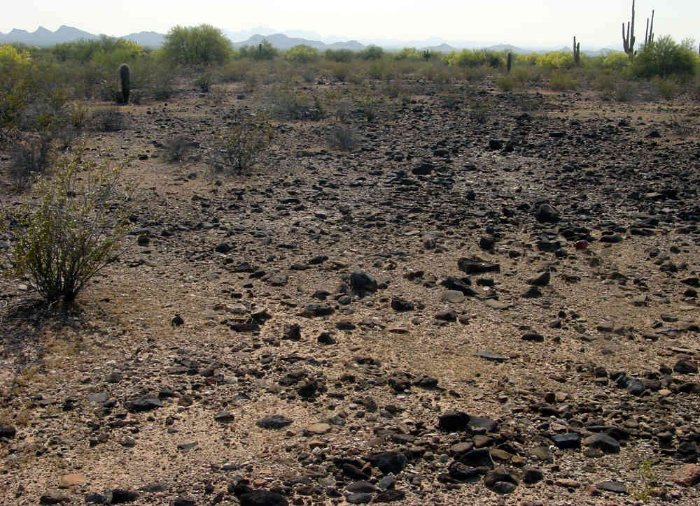
Desert pavement is a flat surface covered with a more or less complete layer of pebbles, gravel, or rocks, caused by the removal of finer sediments from rocky soils or sediments that cover a bajada surface, caused by wind or sheetwash removal of surficial fine material, aided by subsurface upward creep of rocks as fines settle downward in expansive clay-bearing soils. Once formed, desert pavements tend to be long-lasting and stable features, but unfortunately subject to disruption and destruction by human disturbance. On stable desert pavement surfaces, a mysterious process slowly darkens the surfaces exposed to air by slow accumulation of micron-thick black metallic oxide films and clear protein-rich coatings, and simultaneously, red-brown iron oxide staining on the portion of the rocks buried in the soil. In well-developed varnished pavements such as along the lower Colorado River, interstitial fine sediments may consist of a strange crusty 'vesicular silt' horizon of unexplained origin. The scientific value of desert pavement and varnish is that these deposits are a measure of the antiquity of the process and the age of the surface upon which they sit, though techniques are not yet perfected to quantify such relationships. The work of such people as professor Ron Dorn of ASU are trying to bridge this gap. Among other situations, ancient walking trails used by Native Americans, once eroded into varnished pavement surfaces, remain unchanged for thousands of years, such as in the lower Colorado River region, with trailside shrines and archaeological trade debris remaining as evidence for their use. A bit surprisingly, and with few exceptions, only small patches of weakly varnished youthful desert pavement are generally found in the Monument, and displaying very little true varnish effects. In general, only scattered individual rocks within pavement surfaces coated with relict, decomposing varnish and red undercoats were noted for this study except at site S48 on the south flank of the West Silver Bell Mountains. Not unusual, some of the individual varnished rocks were found in overturned positions, with no definite signs such as tracks that cattle were responsible. Sites with some pavement were S2, S4, S13, and S21. Some very weakly varnished pavement patches are found along Silver Bell Road as it approaches and enters the Monument from the east. Two areas displaying varnished pavements were noted during this study. One site is designated S48, on the bajada on the south side of the West Silver Bell Mountains. The pavement patches here lie on a surface which locally sits above some minor inset surfaces containing rills. South of the roadway some smaller pebbles are coated with a very black surface, and an overcoating of shiny clear 'varnish'. Larger rocks have intense red-brown coatings on the undersides. Saguaro distribution, in particular, seems to avoid the dark patches, but fair concentrations of saguaros surround the area where pavement patches prevail. The lateral extent of the dark varnished pavement to the west and south was not ascertained. In the western part of site S48, the varnished pavement layer has been buried beneath a thin mudflow layer which lacks soil development, and more recently the pavement is being re-exposed as the mud erodes off the surface in places. These Holocene mudflow deposits appear to originate far to the east, in the western Silver Bell Mountains, judging upon modern slope gradients.
By far the most extensive and interesting varnished pavements are seen on the west side of the Sawtooth Mountains, with examples all along the powerline road beginning north of the small sand dune field, especially in sections 29, 30, 31, and 32, T 9 S, R 6 E, and section 5, T 10 S, R 6 E. Upon this complex of surfaces flanking the western Sawtooth bajada are found several styles of pavements, from completely varnished patches, to dispersed varnished rocks. Darker varnished surfaces show up as darker tones on aerial photographs. Varnish formation is generally advanced, as coatings are usually very black, and clear varnish coatings are present, sometimes in nearly complete form. In part of the area a 1-3 meter-thick calcrete layer of an old Pleistocene soil is exposed at the surface, covered only by a dispersed layer of dark-varnished rocks that are mixed in with broken pieces of laminar-bedded calcrete. Along the powerline road in the far southeast corner of section 5, 1.5 meters or more of relict clay-rich red-colored paleargid soil horizon is seen covering a thick calcrete, and in turn is covered with dispersed varnished rocks. This is a last vestige of the argillic (red clay-rich) horizon which has been totally stripped away from the western bajada surface, before desert varnish formation. This potentially important site is seen along the roadway. Another variant pavement style is mixtures of pavements made of mostly 10-30 cm-diameter rocks, surrounding rather circular 2-4 meter-diameter patches that contain mostly varnished pebbles (0.5-3 cm diameters). Though it is tempting to say this represents some modification of relict bar-and-swale structure, the circular nature of the pebble groupings is not easily explained. A patch of a totally unvarnished paved surface is seen along the powerline road, for about 1/2 mile north from the north edge of the dune field. This must represent a youthful Holocene debris flow deposit, upon which more recent sheet erosion has begun to wash away fine materials and to create a new pavement. With ground surveying the extent and source of this debris flow could be ascertained. There has been significant disruption of the pavement structure by road and tower construction for the dual powerlines which now cross Aguirre Valley. A photolinear feature
Few roads now cross this part of the Monument. One short E-W segment was visited, where no evidence of origin was noted. Two possibilities exist to explain the trend. The parallel trends could possibly be more than one set of old wagon tracks, used in the 1800-1900s, for access to either possible settlements near (north of) the San Xavier visita from the Tucson or Silver Bell regions, or access to early 1900s cattle operations of the Aguirre family. One possible nearby settlement site is noted below, which lies less than a mile north of the westerly projection of the strongest E-W trend. The other more likely possibility is that the trends are subsidence cracks in the valley surface caused by groundwater and vadose zone soil moisture fluctuations beneath the surface, either natural or as a result of agricultural groundwater pumping. Active agricultural water wells exist now 4-5 miles NNW, and have been pumping for a few decades. However, the strong expression of the linear features seems due to mature trees (mesquites?) which suggest some greater antiquity than 30 years for the feature. According to Mr. Ray Harris of the Arizona Geological Survey, who monitors and records subsidence features, most subsidence cracks occur in en echelon sets (as seen here), but trend parallel to, and in some proximity of, buried Basin and Range faults, or at edges of more extensive playa lakebed sediments such as Willcox playa. Basin and Range faults certainly run more north-south along the sides of Aguirre Valley, since they define its shape, and so an east-west trend of a Basin and Range fault below the linear features, abruptly crossing the valley, is unexpected. However, bedrock distribution at the valley surface (including Koht Kohl Hill on the Reservation) does not preclude that some buried bedrock trend, possibly a Basin and Range structure, cuts across the valley in an east-west direction near the anomaly. Harris (1994) mapped subsidence cracks near Greene's Canal - Friendly Corners area farther north, but has not visited the features noted here. A remote third option exists for their origin, that they are low escarpments of earthquake origin. The nearest earthquake scarps are a short distance southeast of the town of Gila Bend, and several short scarps in the Santa Cruz valley between Tucson and Green Valley. Both sites are nearly 60 miles distant (shown on Kamilli and Richard 1998 map). Only further fieldwork, with possible stratigraphic trenching, may answer the question of the origin of these photolinear features. Other Ground Cracks East of Sawtooth Mountains In the area of Greene Reservoir, just east of the Sawtooth Mountains, a series of ground cracks have recently opened up. Several exist just south of Aires Road, and are mapped and discussed by Harris (1999). They are forming around the Tator Hills (secs 17 & 18, T 10 S, R 7 E, Greene Reservoir quad), and near the center of secs 24 and 25, T 9 S, R 6 E, Greene Reservoir quad), just downstream from the old Greene Reservoir damsite which lies in section 25. This last ground crack location is less than 0.2 mile east of the Monument boundary. They are probably forming because of intense agricultural ground water pumping in the Greene Reservoir area. Considering the probable location of the buried faults, it seems unlikely that cracks should form in this area within Monument lands, but not impossible. Granite pediments
The well-known tendency for granite to quickly decompose in the soil regime, but to 'case harden' in subaerial exposures to the 'balanced boulder' effect, allows for rapid formation of flat gently-sloping granite pediment surfaces adjacent to granite hills. This flat granite surface effect is displayed in several areas of the Monument, such as the abandoned granite quarry in the flat-floored floodplain 3 miles north and east of Ragged Top (site S10). The granite exposed in the quarry has intense weathering for a few meters down, but becomes more fresh at the quarry bottom. A relict soil argillic horizon, overlain by thin Holocene alluvium, cover the obvious trimmed granite pediment surface at the quarry. For example, this well-exposed granite pediment surface is found in the flat portions of sections 17, 18, 19, and 20, T 11 S, R 9 E in the southern Samaniego Hills (Silver Bell East quad), and numerous low knobs indicate the extent of granite bedrock in the valley. Some of the Laramide volcanic assemblages also have the tendency to form flat pediments. Extensive areas of exposed pedimented volcanics are found in the area on the east and north sides of Dos Titos. This pediment covers parts of sections 19, 20, 21, 22, 27 and 28 (T 13 S, R 9 E) on the Waterman Peak quad. Interesting Plant-Soil Relationships Several very curious plant distributions have been noted during the course of this study. They are noted here, to illustrate the rich diversity of situations in the Monument. This author is convinced that it would take concentrated monitoring of soil conditions, especially seasonal distribution of soil moisture content, soluble ions, and soil pH at different depths, over some years of time, to begin to tease out the cause of the distributions noted. At first, it must be noted that there is no general plant-soil equivalency in Ironwood Monument, as can be quickly ascertained by viewing community makeup. (The superconfined distribution of Turk's Head cactus upon certain Permian limestone outcrops like the Horquilla is an interesting anomaly.) As example of diversity of single species, two areas containing concentrated ironwood trees display very divergent substrates. At soil site S37 near Cocoraque Butte, an ironwood thicket with high recruitment of young trees grows in a loose and very pebbly very sandy loam with some minor amounts of interstitial carbonate. Other plants near to the thicket are common creosote, triangle leaf bursage, and staghorn cholla. Saguaros, which are common both downslope and upslope on this bajada, are basically absent within a few hundred meters of the thicket. At another spot, just east of soil site S16, east of Waterman Pass, ironwood trees grow in abundance on a sandstone bedrock knob traversed by the side road, where soil cover is very thin and irregular. The loose sandy loam soils here are very shallow, and root penetration into bedrock, though unknown, is probably minimal. Ironwoods also grow northwest of here in concentration on a south-facing bedrock hillside. Factors other than a certain preferred soil type are involved with ironwood distribution. Other interesting plant-substrate relationships include:
1. A curious and unusual relationship exists between saguaros and a particular Paleozoic sandstone unit called the Abrigo Formation, in the Waterman Mountains. This unit is recognized in the field by its unusual brown weathered color. A ENE-sloping surface of cemented Abrigo sandstones about 500 feet northeast of the top of Waterman Peak (SW 1/4 SW 1/4 sec 30, T 12 S, R 9 E, elevation about 3600 ft and above), contains a very dense stand of saguaros, while virtually none grow on the surrounding rock types, which are composed of limestones and shales. The same relationship of saguaros growing in far greater density upon Abrigo sandstone knobs, than other rock types, is seen in a few spots along the abandoned mine road a few tenths of a mile south of Waterman Peak. There are certainly other sandstone bedrocks in the area with similar fracture or interstitial porosities. This relationship appears to be unexplained. 2. On the northern flank of the Pan Quemado hills two plant distribution effects may be noted. These effects seen in section 26 and adjacent sections, 12S, 9E (Waterman Peak quad). The first is the concentration of creosotebush on bajada surfaces of the lower bajadas of the hills, while within the narrow floodplains and braidplains are concentrated ironwoods, saguaros, mesquites, with or without palo verdes. At the same time, a second parallel differentiation occurs, that of the common ratany growing only on Pleistocene surfaces with the creosotes, while bursage is found within the braidplains, usually on narrow and tiny interfluves (between the channels). The overall character of the soils across this entire area is rather uniform, the braidplain soils somewhat less calcareous within the upper meter than the older Pleistocene soils, but otherwise very similar. The simple issue of occasional flooding may be a controlling factor here. Mark Dimmitt suggests this concentration of ratany is the most obvious such stand in the Monument. 3. The northern hillslope near the western edge of the Monument near Waterman Pass (southern section 7 and northern section 18, 13S, 9E, Waterman Peak quad) contains very well defined plant associations and a distinct community makeup which coincides very closely with change in slope and soil character. The hill is labeled 2624T (1989 edition of the map) and extends across the center of section 18. The soil sites are S14, S15, S16. The hillslope faces due north with slope angles of 15 degrees. It blends into a flat bajada over a short distance. On the flats with a slightly rocky sandy loam soil at least 0.75 m thick, with carbonate increasing with depth, are found creosote, scattered bursage and saguaros and prickly pear, and some teddy bear cholla and barrel cactus. Palo verde trees and some bursage grow thickly on the north-facing hillside, where the surficial soil is very rocky sandy loam with a very thin loam cover. A mature calcrete layer is buried by 0.5 m or so, and visible in places on the steep hillslope. The palo verdes abruptly terminate downslope as the steep hillslope decreases to more moderate angles, but bursage continues downslope and becomes a monotypic stand along a zone that runs along the base of the hill. Just where the land surface flattens out, creosotebush quickly dominates the community, and bursage declines. On the flats, saguaros and mesquites concentrate only along the rills and shallow arroyos in flats otherwise covered by a near monotypic creosote stand. A short distance farther east, the secondary jeep trail access to this site area crosses two gentle bedrock knobs, one covered with a concentration of ocotillos, the other with a thicket of a mix of ocotillos and ironwoods (noted above). Neither of these two species occurs otherwise (except very rarely) in this area described. M. Dimmitt noted a concentration of ironwoods along the northern side of the main valley (northern sec 7, etc.), just north of where the above observations were made. The surficial sediments of the valley are youthful, concentrating there recently enough to have no trace of obvious soil development. (A soil at site S16 near the edge of the valley flats in mixed creosote-mesquite-saguaro is a very calcareous rocky silt loam - difficult to explain, possibly a outcropping of an older valley flat soil which has been largely covered under Holocene sediments.) Though unexplained, this small area noted in this section contains a very tight-fitting plant-to-geomorphic surface relationship. It is curious that the creosote community is situated in the soil type with the greatest infiltration capability, and the palo verdes on steeper slopes where there must be more runoff and less percolation, and yet it is clear that in general creosotes are more drought-tolerant than palo verdes. Some very subtle soil moisture relationship is controlling plant distribution here.
4. In portions of Aguirre Valley are noted peculiar small areas where in comparatively recent times all vegetation has been killed and the spots now exist as bare patches, with still-standing trunks with side branches still standing, or recently toppled. The cause of this disturbance is not immediately obvious. For example, at site S46, on bajada slopes adjacent to the Aguirre Wash braidplain where the overall downvalley gradient is slight, are found an area of creosote-bursage, with spotty cover of a 5-10 cm-tall grass (possibly a Mediterranean import according to Mark Dimmitt). But mixed into these flats are many spots devoid of all vegetation including the grass, that commonly display dead broken trunks where mesquite trees or creosotes once grew. These flats range in size from a few meters across, to the many "mini-playa" flats of the valley, some greater than 5 acres in size. Geologically, the indication is that sedimentation is occuring in these areas, due to some subtle shift of rainfall patterns. In this area, the unvegetated flats seem not to be ablation hollows generated by wind erosion because they are quite level with surrounding vegetated land and seem not 'dished out' at all. In one case a larger bare ground patch sits adjacent to a post-1900 shallow side arroyo, and the surface sediment from the bare ground is washing into the arroyo. Where tested with acid, the top few centimeters of the bare ground patches is no more calcareous than in the surrounding areas. An episode of intense cattle grazing in the past may explain some of this situation. Yjinio Aguirre established a ranch in this region in the 1890s, stretching from the Aguirre Valley eastward to the northern Santa Catalinas where it abutted the Pusch-Zellewager holdings. According to Sheridan (1986), eight to ten thousand cows per year grazed on the ranch, until finally sold by his grandson in the 1970s. There is no obvious evidence that the bare ground patches are sites of recent selective deposition of sheet flood muds, though careful excavation or trenching may obviate this possibility. Recent drought kill of trees-shrubs in the patches does not explain why the grasses do not now grow in the patches. Rather, somehow grass seeds were excluded, buried beneath, or washed away from the bare patches. The patches are not obviously spots of collection of sediments in recent times. Perhaps some kind of salt poisoning from intense cattle grazing throughout the 1900s may explain the anomaly. It is not obvious why vegetation or grasses are not growing in these areas, and, indeed, why there seems to be die-off of trees and shrubs from only these patches. A close-monitored study area could ascertain if the patches were becoming more numerous or growing in size. Two barren flats are obviously growing in size, judging upon recently killed vegetation, located just east and north of the Ray Farnworth ranch house in central Aguirre Valley, partially on the Monument. One site is a flat nearly 10 acres in size, crossing the road along the northern boundary of section 23, T 11 S, R 6 E (Gap Tank quad), and another nearby in the NW quarter of section 15, crossing the road which runs north from the Farnsworth house. At the first site mentioned here, it seems that sedimentation has occurred post-farming, as field side berms seem to have acted as sediment traps. A soil auger hole in a one-acre playa farther southwest at site S42 encountered 55 cm of fine sandy to silty loams, somewhat calcareous, covering a 15 cm thick loose medium-coarse very loamy sand, totally non-calcareous. This sand is the product of some sedimentary process not typical of the playa environment, (appearing more alluvial and not eolian), and so the antiquity of the playa may be questioned. This playa is about 2 miles north of the playa upon which sits the San Xavier visita (site S43). Perhaps the playa environment (the thin clay - mud deposits) as such was not there at the time of human activity, hence perhaps some post-occupational burial has occurred at the site.
This recent killing of vegetation is not noted at another playa site on the southwest flank of the hill called El Cerrito de Represso on the Waterman Peak quad, just south of the cattle tank. This small playa straddles the boundary between sections 13 and 14 (T 13 S, R 9 E). This playa occupies an obvious topographic low, and is of greater antiquity as a depression, and so the playa-side vegetation occupies a more stable or longer-lasting niche. Also, no vegetation killing is noted along the flanks of the large playa south of the Sawtooth Mountains, just south of the Monument boundary.
This same recent patchy dying trend for native vegetation is noted in the Avra Valley, within its floodplain along the east side of Brawley Wash along McGee Road west and south of Marana High School by a few miles. New home owners there are doing intense watering of native vegetation (mesquites, hackberry) with marginal results. The presence of saltbush there may indicate a salinization problem, but from what source? 5. The ratany-bursage situation is also noted on the west flank of the Sawtooth Mountains. Here ratany appears to be the dominant shrub along with creosote on surfaces underlain directly by hard calcrete (which are also covered by scattered varnished rock lags or pavements), while bursage predominates in most places where some thickness of loose alluvium covers the calcrete, for example in narrow and shallow inset terrace deposits along major washes. It is not easy to find field sites where both species commonly coexist. This situation is very similar to other situations noted above, where older, more cemented soil surfaces seem to favor ratany. Also along the powerline road on the west flank of the Sawtooth Mountains, a very obvious ecotone separates creosote flats from gentle higher elevation surfaces covered with palo verdes and creosotebush. This line corresponds exactly with a less-cemented looser alluvial soil that favors the creosote, and hard calcretes exposed at the surface, where the palo verdes grow. This is well exposed along the powerline road traverse as the ecotone that follows the main wash shown on the topographic map which flows southwest, to pass within 0.1 mile north of the far north end of the hill called 'tooth'' (1965 ft elevation). This wash traverses the NW 1/4 of section 8 (Silver Reef Mountains SE quad). Only north of this wash are palo verdes abundant, while to the south is the creosote flat. Alluvial Fans In a region where extensive bajadas really consist of pediment embayments, genuine examples of mountainward-thickening alluvial fans are not always evident or common. Some larger alluvial fans are found in the Santa Cruz and San Pedro Valleys, but are not common within Ironwood Monument. A exemplar alluvial fan debouches from the far south side of Wildcat Peak in the southern Sawtooth Mountains, centered at the mouth of the canyon near the center of the NE 1/4 section 9, T 10 S, R 6 E (Greene Reservoir quad). Subsequent to building the fan, the stream has downcut a channel 2-4 meters below the fan surface. The downstream gradient of this stream is 6-8 degrees in the upper half of the fan, much higher than the gradient on nearby pediment embayments of 1-3 degrees. Alluvial fans were not noticed farther south in the Monument. Talus Slopes Talus slopes are hillslopes composed of loose boulders and rocks that accumulate at the angle of repose (30-32 degrees from the horizontal), fed from a disintegrating cliff above, and under the sole action of gravity, not running water. They are known to be the habitat of a variety of animals ranging from the rock rattlesnake (at higher elevations than occur in IFNM) to terrestrial snails. Only when the cliff above is gone and the supply of boulders cease, does soil slowly form from eolian process, eventually turning the slope into a normal vegetated 'coluvial' slope. Thus the position and frequency of talus slopes and their buried counterparts astride them offer landscape evolution clues to rates and styles of ongoing hillslope processes. More clues of relative rates of talus formation or stability come from the degree of desert varnish on talus boulders, which often is not constant even within a single talus slope. Small talus slopes are not uncommon on hillsides in the Monument. Good examples of larger and more obvious talus slopes exist in a few places: 1. On the northeast and northwest flank of hill 2533, Wildcat Peak, southern Sawtooth Mountains (Greene Reservoir quad). The eastern talus deposit has accumulated at the base of extensive cliffs for more than 50 meter stretch along a west-facing slope, and extends down into a canyon bottom, and into a drainage that eventually flows westward. UTM coordinates for this slope are 3,604,833 N, 430,050 E (Greene Reservoir quad). To the north of here by about one mile, several talus slopes are noted on the western side of Hill 2344 (in southern 1/2 of section 33, T 9 S, R 6 E, Greene Reservoir quad). 2. In the northern Samaniego Hills, on the northern steep flank of Cerro Prieto peak, small talus shoots are noted, but are outsized by a large set of interlaced talus slopes on the north side of the unlabeled hills outside the Monument by just over a mile, especially in section 13, T 10 S, R 8 E (Greene Reservoir quad) At this place, several 'braded' strands cover the hillside due north of peak 2428. Rock Falls Of interest to landscape evolution is the intensity of recent rockfalls. Frequently these are triggered by either local earthquakes or heavy winter rains. One fresh-looking rockfall is seen in the southern Sawtooth Mountains, on Wildcat Peak, located on the western side of the southern prong of the main mountain, some 400 feet northeast of the peak labeled 2533 (Greene Reservoir quad). The rockfall face, and its light-colored scattered debris cone stand out in contrast to the remainder of the varnished hillside. Some individual rocks slipped and rolled to quite near the hill base. Archaeology [Section omitted for security concerns] Sensitive Geologic-Geomorphic sites within Ironwood National Monument Certain desert features found in Ironwood National Monument should be considered sensitive, and very amenable to human-caused disturbance or destruction. They should be considered for protected for their scientific value as much as possible. These include: 1. all sizable areas of desert pavement and bar and swale gravels, whether or not desert varnish is present. These surfaces form very slowly (how slowly is subject to debate), and are easily disturbed or destroyed. At some point in the future these surfaces will provide scientists with indications of their true ages, and will provide time markers for ablated or buried archeology, and Pleistocene geology studies. Their considerable age and unusual history warrants their protection Of particular importance to desert pavement studies is the western flank of the Sawtooth Mountains, where, as noted above, desert pavements of different stages are preserved. 2. the small dune field west of Wildcat Peak in the southern Sawtooth Mountains is the is the best example of dunes in the Monument, including endemic big Galleta grass. These dunes are extremely sensitive to disturbance, and should be protected. 3. certain sites where cryptobiotic crusts (biological soil crusts) are present. Perhaps an off-limits study site for this sensitive and easily-destroyed ecosystem could be designated. A site survey could locate best areas for protection. A potentially uncommon cryptobiotic crust (a type unknown to this author) was noted in the area of site S48, on the north side of the road, where 5-10 cm-diameter round black-colored dessicated masses were noted. 4. bedrock cliffs where thick coverage of lichens are found. (Example: the cliffs on the west side of the hill which lies west of the Pan Quemado hills, and in the southeastern extension of the Waterman Mountains. This hill, thickly covered with a bright green lichen species, lies in the southwest quarter of section 3, T 13 S, R 9 E (Waterman Peak quad.) Another patch of many mixed multi-colored species was noted on the northeast-facing cliff composed of volcanic breccia on the small hillside near the center of the south 1/2, section 9, T 10 S, R 6 E (southwestern Sawtooth Mountains, Silver Reef Mtns SE quad). On this hillside, near the path of the dual regional electrical lines, the breccia layer on the hill's midslope has the thickest coverage, approaching 100%, while two welded ash flow layers outcropping higher on the hill and nearer the electrical lines display more moderate concentrations on identical slope aspects. At this site, interesting studies could be made of factors which control lichen distribution. 5. sites of longer-lasting playa sedimentation, consisting of clays and muds, such as the site noted above at El Cerrito de Represso. Besides harboring potential wildlife such as spadefoot toads, these sites may contain sediment history of Pleistocene events and climates in their record of buried organic matter and pollen. These sensitive sites, where off-road vehicular traffic tends to congregate, should not be disturbed. The largest playa in the area, lying south of Wildcat Peak in the southern Sawtooth Mountains, lies outside the Monument, but probably records significant late Pleistocene geologic sedimentary history. Other smaller playas, such as one that the Cocoraque ranch road crosses (NE 1/4 sec 2, 14 S, 10E, Cocoraque Butte quad) probably have a shorter history, but may harbor valuable sedimentary history of Holocene time. 6. mammal fossil sites. As elsewhere in southern Arizona, late Pleistocene deposits adjacent to floodplains or braidplains contain a famous assortment of mammal fossils, famous in the San Pedro Valley to the east. But such unexcavated sites are also known along Brawley Wash in the Avra Valley west of the town of Marana (a mammoth site), and southward near the Arizona-Sonora Desert Museum, where hardened trackway and a very rare complete skull of Camelops , a North American camel, were recovered in the early 1990s. The camel site was visited and sampled by Dr. C. Vance Haynes of the University of Arizona in the early 1990s, who confirmed a Carbon-14 late Pleistocene age (about 12,000 years ago). Both of these sites are on record at the Arizona State Museum. Though differing in details of late Pleistocene and Holocene downcut-backfill history, there is distinct potential for similar sites along the extensive braidplain environment of Aguirre Wash, especially considering that the site later was livable for Native Americans who probably did seasonal subsistence agriculture, and where finally was erected a San Xavier Mission outpost visita in the 1800s to attend to a lingering population. 7. archaeological sites. Two general areas are noted [omitted for security concerns] Acknowledgments Thanks are given to Steve Shetron, ASDM volunteer and soil scientist, who assisted with soils identification, and to Mark Dimmitt and Tom Van Devender of the Arizona-Sonora Desert Museum for helpful discussions, shared field time, and helpful review of this paper. GEOLOGIC REFERENCES FOR IRONWOOD NATIONAL MONUMENTFerguson, C.A., Gilbert, W.G., Klawon, J.E., Pearthree, P.A., and Peters, Lisa, 1999, Geologic map of the Sawtooth Mountains and the north end of the West Silver Bell Mountains, Pinal and Pima Counties, southern Arizona. Arizona Geological Survey Open-File Report 99-16. map scale 1:24,000. Ferguson, C.A., Gilbert, W.G., Orr, T.R., Spencer, J.E., Richard, S.M., Pearthree, P.A., and Peters, Lisa, 2000. Geologic map of the Samaniego Hills, Pinal and Pima Counties, Arizona. Arizona Geological Survey Open-File Report 99-17, 17 p, map scale 1:24,000. Field, J.J., and Pearthree, P.A., 1993, Surficial geologic maps of the northern Avra Valley-Desert Peak area, Pinal and Pima Counties, southern Arizona. Arizona Geological Survey Open-File Report 93-13, 11 p, and nine geologic maps of 7.5' quadrangles, scale 1:24,000. Geologic map of the West of Avra 7.5' quadrangle, Pima County, Arizona. Arizona Geological Survey DGM-05. Harris, R.C., 1994, A reconnaissance of earth fissures near Apache Junction, Chandler Heights, and southwestern Picacho Basin. Arizona Geological Survey Open-File Report, 94-11, 5 p. and two maps. Harris, R.C., 1999, Field guide to earth fissures and other land subsidence features in Picacho Basin. Arizona Geological Survey Open-File Report 99-26, 55 p. Harris, R.C., and Trapp, R.A., 2000. Bibliography of the geology and mineral resources of Ironwood Forest National Monument, Pima and Pinal Counties, Arizona. Arizona Geological Survey Open-File Report 00-15. 18 p. Kamilli, R.J., and Richard, S.M. [editors], 1998, Geologic highway map of Arizona. Arizona Geological Society and Arizona Geological Survey, Tucson. Map scale 1: one million. Pearthree, P.A., McKittrick, M.A., Jackson, G.W.,, and Demsey, K.A., 1988, Geologic map of Quaternary and upper Tertiary deposits, Tucson 1X2 degree Quadrangle, Arizona. Arizona Geological Survey Open-File Report 88-21. map scale 1:250,000. Peirce, H.W., 1976, Tectonic significance of Basin and Range thick evaporite deposits. Arizona Geological Society Digest, v. 10, p. 325-339. Richard, S.M., Ferguson, C.A., Spencer, J.E., Youberg, Ann, and Orr, T.R., 2000. Geologic map of the Waterman Peak and northern La Tortuga Butte 7.5' quadrangles, Pima County, Arizona. Arizona Geological Survey DGM-02. Roeske, R.H., Garrett, J.M., and Eychaner, J.H., 1989, Floods of October 1983 in southeastern Arizona. U.S. Geological Survey Water-Resources Investigations Report 85-4225-C, 77 p. Sawyer, D.A., 1996, Geologic map of the Silver Bell and West Silver Bell Mountains, southern Arizona. U.S. Geological Survey Open-file Report 96-006. map scale 1:24,000. Sheridan, T.E., 1986, Los Tucsonenses: the Mexican Community in Tucson, 1854-1941. University of Arizona Press, Tucson. (page 52 discusses the Aguirre family's ranches.) Skotnicki, S.J., and Pearthree, P.A., 2000, Geologic map of the Cocoraque Butte 7.5' quadrangle, Pima County, Arizona. Arizona Geological Survey DGM-06, and hard copy Open-File Report 00-08 dated September 2000, 27 p., map scale 1:24,000. Stoyanow, A.A., 1949, Lower Cretaceous stratigraphy in southeastern Arizona. Geological Society of America Memoir 38, 169 p. Titley, S.R., and Anthony, E.Y., 1989, Laramide Mineral deposits in Arizona. In Jenney, J.P. and Reynolds S.J. [editors], 1989, Geologic evolution of Arizona: Tucson, Arizona Geological Society Digest 17, p. 485-514. Wood, M.L., House, P.K., and Pearthree, P.A., 1999, Historical geomorphology and hydrology of the Santa Cruz River. Arizona Geological Survey Open-File Report 99-13, 98 p. and one map 1:100,000.
|
|
